
Carte topographique Lecco
Carte interactive
Cliquez sur la carte pour afficher l’altitude.
À propos de cette carte
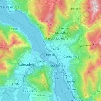
Nom : Carte topographique Lecco, altitude, relief.
Lieu : Lecco, Lombardy, 23900, Italy (45.81219 9.36677 45.90614 9.48490)
Altitude moyenne : 575 m
Altitude minimum : 193 m
Altitude maximum : 1 647 m
The territory has a very variable altimeter distribution: it ranges from 198 metres (650 ft) above sea level in the lake area to the maximum altitude of 1,875 metres (6,152 ft) above the sea level of Mount Resegone and this condition offers the city three different areas characterized by different morphologic and climatic characteristics.
Autres cartes topographiques
Cliquez sur une carte pour visualiser sa topographie, son altitude et son relief.
Monte Resegone
Italy > Lombardy > Lecco > Lecco
Monte Resegone, Lecco, Lombardy, 23900, Italy
Altitude moyenne : 1 371 m
Oliveto Lario
Oliveto Lario, Lecco, Lombardy, 23865, Italy
Altitude moyenne : 569 m