Géolocaliser

Carte topographique Geisenried

Carte interactive

Cliquez sur la carte pour afficher l’altitude.

À propos de cette carte

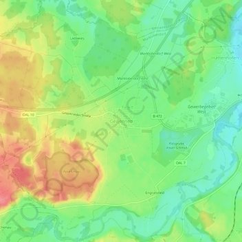
Nom : Carte topographique Geisenried, altitude, relief.

Lieu : Geisenried, Marktoberdorf, Landkreis Ostallgäu, Bayern, 87616, Deutschland (47.75048 10.54212 47.79048 10.58212)

Altitude moyenne : 753 m

Altitude minimum : 719 m

Altitude maximum : 797 m

Autres cartes topographiques

Cliquez sur une carte pour visualiser sa topographie, son altitude et son relief.

Mühlbichel

Deutschland > Bayern > Landkreis Ostallgäu > Marktoberdorf > Ronried

Mühlbichel, Ronried, Marktoberdorf, Landkreis Ostallgäu, Bayern, 87616, Deutschland

Altitude moyenne : 769 m

Am Schillenberg

Deutschland > Bayern > Landkreis Ostallgäu > Marktoberdorf

Am Schillenberg, Marktoberdorf, Landkreis Ostallgäu, Bayern, 87616, Deutschland

Altitude moyenne : 748 m

Bertoldshofen

Deutschland > Bayern > Landkreis Ostallgäu > Marktoberdorf

Bertoldshofen, Marktoberdorf, Landkreis Ostallgäu, Bayern, 87616, Deutschland

Altitude moyenne : 752 m

Sulzschneid

Deutschland > Bayern > Landkreis Ostallgäu > Marktoberdorf

Sulzschneid, Marktoberdorf, Landkreis Ostallgäu, Bayern, 87663, Deutschland

Altitude moyenne : 775 m