
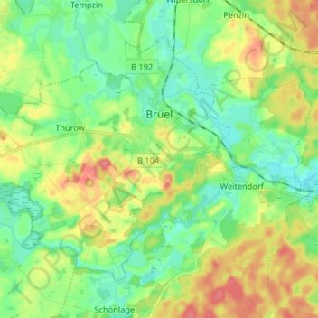
Carte topographique Brüel
Carte interactive
Cliquez sur la carte pour afficher l’altitude.
À propos de cette carte
Nom : Carte topographique Brüel, altitude, relief.
Altitude moyenne : 32 m
Altitude minimum : 8 m
Altitude maximum : 73 m
Autres cartes topographiques
Cliquez sur une carte pour visualiser sa topographie, son altitude et son relief.
Vielank
Germany > Mecklenburg-Vorpommern > Ludwigslust-Parchim
Vielank, Dömitz-Malliß, Ludwigslust-Parchim, Mecklenburg-Vorpommern, Germany
Altitude moyenne : 20 m
Valluhn
Germany > Mecklenburg-Vorpommern > Ludwigslust-Parchim > Lüttow-Valluhn
Valluhn, Lüttow-Valluhn, Zarrentin, Ludwigslust-Parchim, Mecklenburg-Vorpommern, Germany
Altitude moyenne : 32 m
Below
Germany > Mecklenburg-Vorpommern > Ludwigslust-Parchim > Below
Below, Techentin, Goldberg-Mildenitz, Ludwigslust-Parchim, Mecklenburg-Vorpommern, 19399, Germany
Altitude moyenne : 66 m
Ludwigslust
Germany > Mecklenburg-Vorpommern > Ludwigslust-Parchim
Ludwigslust, Ludwigslust-Parchim, Mecklenburg-Vorpommern, 19288, Germany
Altitude moyenne : 32 m
Parchim
Germany > Mecklenburg-Vorpommern > Ludwigslust-Parchim
Parchim, Ludwigslust-Parchim, Mecklenburg-Vorpommern, Germany
Altitude moyenne : 61 m
Warsow
Germany > Mecklenburg-Vorpommern > Ludwigslust-Parchim
Warsow, Stralendorf, Ludwigslust-Parchim, Mecklenburg-Vorpommern, Germany
Altitude moyenne : 45 m