
Carte topographique Swiftcurrent Glacier
Carte interactive
Cliquez sur la carte pour afficher l’altitude.
À propos de cette carte
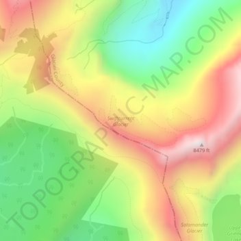
Nom : Carte topographique Swiftcurrent Glacier, altitude, relief.
Altitude moyenne : 2 062 m
Altitude minimum : 1 594 m
Altitude maximum : 2 579 m
Autres cartes topographiques
Cliquez sur une carte pour visualiser sa topographie, son altitude et son relief.
Devils Slide
Devils Slide, Many Glacier Road, Babb, Glacier County, Montana, 59411, USA
Altitude moyenne : 1 502 m
Agassiz Glacier
USA > Montana > Wurtz Hill
Agassiz Glacier, Boulder Pass, Wurtz Hill, Flathead County, Montana, USA
Altitude moyenne : 2 376 m
Vulture Glacier
Vulture Glacier, Logging Lake, Flathead County, Montana, USA
Altitude moyenne : 2 381 m
Harris Glacier
USA > Montana > Wurtz Hill
Harris Glacier, Boulder Pass, Wurtz Hill, Flathead County, Montana, USA
Altitude moyenne : 2 138 m
Harrison Glacier
Harrison Glacier, Gunsight Pass, Flathead County, Montana, USA
Altitude moyenne : 2 364 m
Sperry Glacier
Sperry Glacier, Sperry Lake, Flathead County, Montana, USA
Altitude moyenne : 2 382 m
Herbst Glacier
USA > Montana > Wurtz Hill
Herbst Glacier, Boulder Pass, Wurtz Hill, Flathead County, Montana, USA
Altitude moyenne : 2 019 m
Two Ocean Glacier
Two Ocean Glacier, Logging Lake, Flathead County, Montana, USA
Altitude moyenne : 2 331 m
Crazy Mountains Historical Marker
Crazy Mountains Historical Marker, Wheatland County, Montana, USA
Altitude moyenne : 1 315 m
Baby Glacier
Baby Glacier, Bowman Lake, Flathead County, Montana, USA
Altitude moyenne : 2 009 m
Sundance Glacier
Sundance Glacier, Carbon County, Montana, USA
Altitude moyenne : 3 488 m
Kintla Glacier
USA > Montana > Wurtz Hill
Kintla Glacier, Boulder Pass, Wurtz Hill, Flathead County, Montana, USA
Altitude moyenne : 2 336 m
Young Man Lake
Young Man Lake, Oldman Lake, Glacier County, Montana, USA
Altitude moyenne : 2 169 m
Blackwell Glacier
Blackwell Glacier, Leigh Lake Trail, Lincoln County, Montana, USA
Altitude moyenne : 2 114 m
Thunderbird Glacier
USA > Montana > Wurtz Hill
Thunderbird Glacier, Boulder Pass, Wurtz Hill, Flathead County, Montana, USA
Altitude moyenne : 2 162 m
Blacktail Mountains
Blacktail Mountains, Beaverhead County, Montana, USA
Altitude moyenne : 2 697 m
Ipasha Glacier
Ipasha Glacier, Highline Trail, Flathead County, Montana, USA
Altitude moyenne : 2 122 m
Independence Peak
Independence Peak, Lincoln County, Montana, USA
Altitude moyenne : 1 895 m
Grasshopper Glacier
Grasshopper Glacier, Carbon County, Montana, USA
Altitude moyenne : 3 407 m
Blackfoot Glacier
Blackfoot Glacier, Jackson Glacier, Glacier County, Montana, USA
Altitude moyenne : 2 286 m
Stanton Glacier
Stanton Glacier, National Forest Development Road 38, Flathead County, Montana, USA
Altitude moyenne : 2 194 m
Jackson Peak
Jackson Peak, Lewis and Clark County, Montana, USA
Altitude moyenne : 1 271 m
Old Sun Glacier
Old Sun Glacier, Stoney Indian Pass, Glacier County, Montana, USA
Altitude moyenne : 2 285 m
Pumpkin Glacier
Pumpkin Glacier, Jackson Glacier, Glacier County, Montana, USA
Altitude moyenne : 2 316 m
Dixon Glacier
USA > Montana > Wurtz Hill
Dixon Glacier, Boulder Pass, Wurtz Hill, Flathead County, Montana, USA
Altitude moyenne : 2 192 m
Whitecrow Glacier
Whitecrow Glacier, Stoney Indian Pass, Glacier County, Montana, USA
Altitude moyenne : 2 339 m
Shepard Glacier
Shepard Glacier, Highline Trail, Flathead County, Montana, USA
Altitude moyenne : 2 156 m
Weasel Collar Glacier
Weasel Collar Glacier, Bowman Lake, Flathead County, Montana, USA
Altitude moyenne : 2 290 m
Lupfer Glacier
Lupfer Glacier, Coal Creek, Flathead County, Montana, USA
Altitude moyenne : 2 047 m
Phantom Glacier
Phantom Glacier, Clarks Fork Trail, Carbon County, Montana, USA
Altitude moyenne : 3 248 m
Wolf Glacier
Wolf Glacier, Goose Lake Jeep Trail, Park County, Montana, USA
Altitude moyenne : 3 144 m
Piegan Glacier
Piegan Glacier, Piegan Pass Trail, Glacier County, Montana, USA
Altitude moyenne : 2 222 m
Paul Bunyans Cabin
Paul Bunyans Cabin, Flathead County, Montana, USA
Altitude moyenne : 2 099 m