
Carte topographique Lansing
Carte interactive
Cliquez sur la carte pour afficher l’altitude.
À propos de cette carte
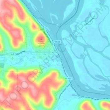
Nom : Carte topographique Lansing, altitude, relief.
Lieu : Lansing, Allamakee County, Iowa, United States (43.34660 -91.25598 43.37533 -91.20717)
Altitude moyenne : 228 m
Altitude minimum : 186 m
Altitude maximum : 340 m
Autres cartes topographiques
Cliquez sur une carte pour visualiser sa topographie, son altitude et son relief.
New Albin
United States > Iowa > Allamakee County
New Albin, Allamakee County, Iowa, United States
Altitude moyenne : 209 m
Waukon
United States > Iowa > Allamakee County
Waukon, Allamakee County, Iowa, 52172, United States
Altitude moyenne : 373 m
Dorchester
United States > Iowa > Allamakee County
Dorchester, Allamakee County, Iowa, 52140, United States
Altitude moyenne : 300 m
Postville
United States > Iowa > Allamakee County
Postville, Allamakee County, Iowa, United States
Altitude moyenne : 355 m
Elon
United States > Iowa > Allamakee County
Elon, Allamakee County, Iowa, United States
Altitude moyenne : 335 m
Waterville
United States > Iowa > Allamakee County
Waterville, Allamakee County, Iowa, United States
Altitude moyenne : 291 m
Harpers Ferry
United States > Iowa > Allamakee County
Harpers Ferry, Allamakee County, Iowa, United States
Altitude moyenne : 214 m