
Carte topographique Xã Thanh Sơn
Carte interactive
Cliquez sur la carte pour afficher l’altitude.
À propos de cette carte
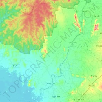
Nom : Carte topographique Xã Thanh Sơn, altitude, relief.
Lieu : Xã Thanh Sơn, Định Quán District, Đồng Nai Province, Vietnam (11.19345 107.15882 11.39717 107.35787)
Altitude moyenne : 125 m
Altitude minimum : 51 m
Altitude maximum : 334 m
Autres cartes topographiques
Cliquez sur une carte pour visualiser sa topographie, son altitude et son relief.
Định Quán
Vietnam > Dong Nai province > Định Quán District
Định Quán, Định Quán District, Đồng Nai Province, Vietnam
Altitude moyenne : 141 m