
Carte topographique Saint Petersburg
Carte interactive
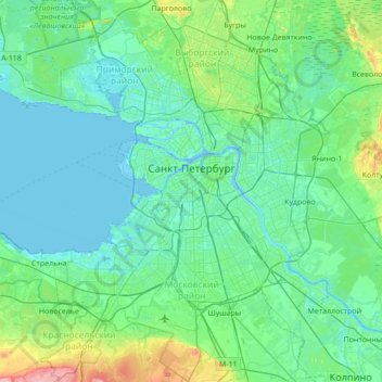
Cliquez sur la carte pour afficher l’altitude.
À propos de cette carte
Nom : Carte topographique Saint Petersburg, altitude, relief.
Lieu : Saint Petersburg, Northwestern Federal District, Russia (59.74415 30.04334 60.09074 30.56717)
Altitude moyenne : 17 m
Altitude minimum : -3 m
Altitude maximum : 118 m
The elevation of Saint Petersburg ranges from the sea level to its highest point of 175.9 m (577 ft) at the Orekhovaya Hill in the Duderhof Heights in the south. Part of the city's territory west of Liteyny Prospekt is no higher than 4 m (13 ft) above sea level, and has suffered from numerous floods. Floods in Saint Petersburg are triggered by a long wave in the Baltic Sea, caused by meteorological conditions, winds and shallowness of the Neva Bay. The five most disastrous floods occurred in 1824 (4.21 m or 13 ft 10 in above sea level, during which over 300 buildings were destroyed); 1924 (3.8 m, 12 ft 6 in); 1777 (3.21 m, 10 ft 6 in); 1955 (2.93 m, 9 ft 7 in); and 1975 (2.81 m, 9 ft 3 in). To prevent floods, the Saint Petersburg Dam has been constructed.
Autres cartes topographiques
Cliquez sur une carte pour visualiser sa topographie, son altitude et son relief.
округ Московская застава
округ Московская застава, Московский район, Saint Petersburg, Northwestern Federal District, 190000, Russia
Altitude moyenne : 10 m
Saint Petersburg
Saint Petersburg, Northwestern Federal District, 190000, Russia
Altitude moyenne : 40 m
округ Звёздное
Russia > Saint Petersburg > округ Звёздное
округ Звёздное, Московский район, Saint Petersburg, Northwestern Federal District, 190000, Russia
Altitude moyenne : 16 m
Владимирский округ
Russia > Saint Petersburg > Владимирский округ
Владимирский округ, Центральный район, Saint Petersburg, Northwestern Federal District, 190000, Russia
Altitude moyenne : 13 m