
Carte topographique Nabay
Carte interactive
Cliquez sur la carte pour afficher l’altitude.
Nabay
Nabay (Arabic: نابيه, from the Aramaic: נביא ; ܢܒܺܝܶ̈ܐ) is a village located in the Matn District (kada), Mount Lebanon Governorate (Mohafazat). Nabay is located 16 kilometers (9.9424 mi) away from the capital Beirut. Its elevation is 500 meters (1640.5 ft - 546.8 yd) above sea level. Nabay surface stretches for 388 hectares (3.88 km² - 1.49768 mi²).
À propos de cette carte
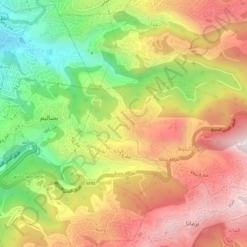
Nom : Carte topographique Nabay, altitude, relief.
Lieu : Nabay, Matn District, Mount Lebanon Governorate, 1204, Lebanon (33.87904 35.59888 33.91904 35.63888)
Altitude moyenne : 443 m
Altitude minimum : 19 m
Altitude maximum : 829 m
Autres cartes topographiques
Cliquez sur une carte pour visualiser sa topographie, son altitude et son relief.
Baskinta
Lebanon > Mount Lebanon Governorate
Baskinta (Arabic: بسكنتا) is a Lebanese village situated at an altitude ranging from 1250 metres above sea level and climbs up to approximately 1800 meters of height at Qanat Bakish, making it one of the highest villages of Lebanon. It is located 43 kilometers north east of Beirut.
Altitude moyenne : 1 396 m
Ain Saadeh
Lebanon > Mount Lebanon Governorate
The average annual rainfall is 825 millimetres (32.5 in), with the large majority of it falling from October to April. Much of the autumn and spring rain falls in heavy downpours on a limited number of days, but in winter it is spread more evenly over many days. Summer receives very little rainfall, if any.…
Altitude moyenne : 335 m
Beit Mery
Lebanon > Mount Lebanon Governorate
1) Beit Mery I is on the right bank of the Beirut River, south southwest of the town at an altitude of approximately 125 metres (410 ft) above sea level. It was found by Jesuit Father Dillenseger who determined it to be an Acheulean site. The material was donated to the Saint Joseph University by the French…
Altitude moyenne : 460 m
Aley
Lebanon > Mount Lebanon Governorate
The word "Aley" means "high place" in Arabic and in Aramaic, referring to the city's high altitude above sea level (from 600m up to 950m).
Altitude moyenne : 775 m
Antelias
Lebanon > Mount Lebanon Governorate
The municipality of Antelias - Naqqach is located in the Kaza of Matn in Mount Lebanon, one of the eight mohafazats (governorates) of Lebanon. Antelias - Naqqach is 8 kilometers (4.9712 mi) from Beyrouth (Beirut), the capital of Lebanon. Its elevation is 10 meters (32.81 ft; 10.936 yd) above sea level.…
Altitude moyenne : 65 m
Aley
Lebanon > Mount Lebanon Governorate
The word "Aley" means "high place" in Arabic and in Aramaic, referring to the city's high altitude above sea level (from 600m up to 950m).
Altitude moyenne : 775 m