
Carte topographique Nong Mae Mai Lake
Carte interactive
Cliquez sur la carte pour afficher l’altitude.
À propos de cette carte
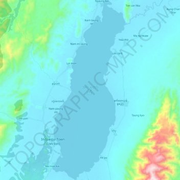
Nom : Carte topographique Nong Mae Mai Lake, altitude, relief.
Lieu : Nong Mae Mai Lake, Mohnyin District, Kachin, Myanmar (25.04568 96.28649 25.26116 96.38490)
Altitude moyenne : 249 m
Altitude minimum : 164 m
Altitude maximum : 1 023 m
Autres cartes topographiques
Cliquez sur une carte pour visualiser sa topographie, son altitude et son relief.
Mogaung Township
Myanmar > Kachin > Mohnyin District > Mogaung Township
Mogaung Township, Mohnyin District, Kachin, ၁၁၀၂, Myanmar
Altitude moyenne : 346 m
Mohnyin Township
Myanmar > Kachin > Mohnyin District
Mohnyin Township, Mohnyin District, Kachin, Myanmar
Altitude moyenne : 350 m