
Faire un don
Équipez-vous pour votre prochaine aventure :
En tant que Partenaire Amazon, ce site perçoit une commission sur les achats éligibles sans surcoût pour vous.
Carte topographique Durango
Cliquez sur la carte pour afficher l’altitude.
Faire un don
Équipez-vous pour votre prochaine aventure :
En tant que Partenaire Amazon, ce site perçoit une commission sur les achats éligibles sans surcoût pour vous.
Durango
Durango is located at 37°16′N 107°52′W / 37.267°N 107.867°W / 37.267; -107.867 at an elevation of 6,512 ft (1,988 m). At the 2020 United States Census, the town had a total area of 10,946 acres (44.296 km2) including 1,533 acres (6.203 km2) of water.
Faire un don
Équipez-vous pour votre prochaine aventure :
En tant que Partenaire Amazon, ce site perçoit une commission sur les achats éligibles sans surcoût pour vous.
À propos de cette carte
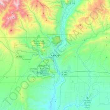
Nom : Carte topographique Durango, altitude, relief.
Lieu : Durango, La Plata County, Colorado, 81302, United States (37.11695 -108.03660 37.43695 -107.71660)
Altitude moyenne : 2 360 m
Altitude minimum : 1 872 m
Altitude maximum : 3 946 m
Faire un don
Équipez-vous pour votre prochaine aventure :
En tant que Partenaire Amazon, ce site perçoit une commission sur les achats éligibles sans surcoût pour vous.