Géolocaliser

Carte topographique Burlington

Cliquez sur la carte pour afficher l’altitude.

À propos de cette carte

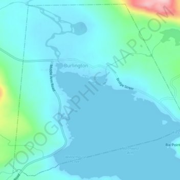
Nom : Carte topographique Burlington, altitude, relief.

Lieu : Burlington, Newfoundland, Newfoundland and Labrador, Canada (49.73449 -56.03270 49.76025 -55.99190)

Altitude moyenne : 28 m

Altitude minimum : -2 m

Altitude maximum : 219 m

Autres cartes topographiques

Cliquez sur une carte pour visualiser sa topographie, son altitude et son relief.

Grosse Point

Canada > Newfoundland and Labrador

Altitude moyenne : 25 m

Mount Caubvick

Canada > Newfoundland and Labrador

Altitude moyenne : 1 272 m

Highway 220

Canada > Newfoundland and Labrador

Altitude moyenne : 8 m

Monroe

Canada > Newfoundland and Labrador

Altitude moyenne : 41 m

Englee

Canada > Newfoundland and Labrador > Englee

Altitude moyenne : 34 m

Labrador

Canada > Newfoundland and Labrador

Altitude moyenne : 674 m

Bridgeport

Canada > Newfoundland and Labrador

Altitude moyenne : 22 m

Bell Island

Canada > Newfoundland and Labrador

Altitude moyenne : 9 m

East Point

Canada > Newfoundland and Labrador

Altitude moyenne : 2 m

Jeffrey's

Canada > Newfoundland and Labrador

Altitude moyenne : 21 m

Smokey

Canada > Newfoundland and Labrador > Smokey

Altitude moyenne : 14 m

St. Thomas

Canada > Newfoundland and Labrador > Paradise

Altitude moyenne : 61 m

Tims Hill

Canada > Newfoundland and Labrador

Altitude moyenne : 126 m

Valley Pond

Canada > Newfoundland and Labrador

Altitude moyenne : 15 m

Équipez-vous pour votre prochaine aventure :

🧣Cache-cou multifonction UV - Protection contre le vent et le soleil
🚲Support smartphone pour vélo - Utilisez topographic-map.com en direct sur votre guidon
🕶️Lunettes polarisées outdoor - Lunettes pour réduire l'éblouissement en nature
🧳Sacs étanches - Protection du matériel contre l'eau
🍳Cuisine de camping - Ustensiles et casseroles pour le bivouac

En tant que Partenaire Amazon, ce site perçoit une commission sur les achats éligibles sans surcoût pour vous.