
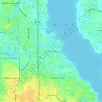
Carte topographique Lake Shore Estates
Carte interactive
Cliquez sur la carte pour afficher l’altitude.
À propos de cette carte
Nom : Carte topographique Lake Shore Estates, altitude, relief.
Altitude moyenne : 9 m
Altitude minimum : -2 m
Altitude maximum : 28 m
Autres cartes topographiques
Cliquez sur une carte pour visualiser sa topographie, son altitude et son relief.
Acklocknayke (historical)
United States > Florida > Pinellas County > Palm Harbor
Acklocknayke (historical), Palm Harbor, Pinellas County, Florida, 34681, United States
Altitude moyenne : 3 m
Honeymoon Island Dog Beach
United States > Florida > Pinellas County > Palm Harbor
Honeymoon Island Dog Beach, Causeway Boulevard, Palm Harbor, Pinellas County, Florida, 34660, United States
Altitude moyenne : 0 m