
Faire un don
Équipez-vous pour votre prochaine aventure :
En tant que Partenaire Amazon, ce site perçoit une commission sur les achats éligibles sans surcoût pour vous.
Carte topographique Pleinfeld
Cliquez sur la carte pour afficher l’altitude.
Faire un don
Équipez-vous pour votre prochaine aventure :
En tant que Partenaire Amazon, ce site perçoit une commission sur les achats éligibles sans surcoût pour vous.
Pleinfeld
Pleinfeld is situated on the rivers Swabian Rezat and Arbach, 8 kilometres (5.0 mi) north of Weißenburg in Bayern, and 45 kilometres (28 mi) south of Nuremberg. Other rivers in the municipality area are Brombach river and Banzerbach river, both tributary of the Swabian Rezat. The town's altitude is around 382 metres (1,253 feet) above sea level. The highest point of the municipality is located near Dorsbrunn, 505 m (1,657 ft) asl. Pleinfeld is the biggest town at the Großer Brombachsee, a lake in the Franconian Lake District. Simultaneously, Pleinfeld is located on the most northern part of the Altmühl Valley Nature Park.
Faire un don
Équipez-vous pour votre prochaine aventure :
En tant que Partenaire Amazon, ce site perçoit une commission sur les achats éligibles sans surcoût pour vous.
À propos de cette carte
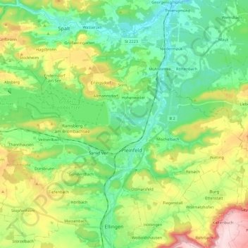
Nom : Carte topographique Pleinfeld, altitude, relief.
Lieu : Pleinfeld, Weißenburg-Gunzenhausen, Bavaria, 91785, Germany (49.08332 10.87587 49.15750 11.09330)
Altitude moyenne : 431 m
Altitude minimum : 342 m
Altitude maximum : 618 m
Faire un don
Équipez-vous pour votre prochaine aventure :
En tant que Partenaire Amazon, ce site perçoit une commission sur les achats éligibles sans surcoût pour vous.
Autres cartes topographiques
Cliquez sur une carte pour visualiser sa topographie, son altitude et son relief.
Faire un don
Équipez-vous pour votre prochaine aventure :
En tant que Partenaire Amazon, ce site perçoit une commission sur les achats éligibles sans surcoût pour vous.