
Carte topographique Dahanu
Cliquez sur la carte pour afficher l’altitude.
Dahanu
Dahanu is located at 19°58′N 72°44′E / 19.97°N 72.73°E / 19.97; 72.73. It has an average elevation of 9.89 metres. To the west of the town is the coast of the Arabian Sea while the east is lined with the Sahyadri ranges. This combination has made Dahanu a tourist destination. Sprawling Chickoo wadis (farms), rose gardens, salt pans are among the other things that dot the landscape.
À propos de cette carte
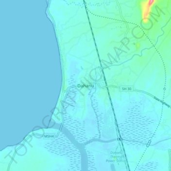
Nom : Carte topographique Dahanu, altitude, relief.
Lieu : Dahanu, Dahanu Taluka, Palghar, Maharashtra, 401600, India (19.94872 72.69385 20.02872 72.77385)
Altitude moyenne : 9 m
Altitude minimum : -2 m
Altitude maximum : 122 m