
Carte topographique Pine
Carte interactive
Cliquez sur la carte pour afficher l’altitude.
À propos de cette carte
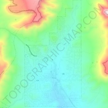
Nom : Carte topographique Pine, altitude, relief.
Lieu : Pine, Gila County, Arizona, 85544, United States (34.37097 -111.47143 34.41879 -111.44099)
Altitude moyenne : 1 794 m
Altitude minimum : 1 613 m
Altitude maximum : 2 221 m
Pine and the adjacent community of Strawberry are rapidly growing vacation and retirement centers in north-central Arizona, below the Mogollon Rim. Pine's elevation is 5,448 feet (1,661 m), and the Pine post office was established in 1884.
Autres cartes topographiques
Cliquez sur une carte pour visualiser sa topographie, son altitude et son relief.
Payson
United States > Arizona > Gila County
Payson, Gila County, Arizona, 85072, United States
Altitude moyenne : 1 522 m
White Tank
United States > Arizona > Gila County
White Tank, Gila County, Arizona, United States
Altitude moyenne : 1 298 m
White Mountain
United States > Arizona > Gila County
White Mountain, Gila County, Arizona, United States
Altitude moyenne : 1 363 m
Miami
United States > Arizona > Gila County
Miami, Gila County, Arizona, 85539, United States
Altitude moyenne : 1 121 m
Globe
United States > Arizona > Gila County
Globe, Gila County, Arizona, 85532, United States
Altitude moyenne : 1 173 m
Cypress Hill
United States > Arizona > Gila County > Star Valley
Cypress Hill, Star Valley, Gila County, Arizona, United States
Altitude moyenne : 1 440 m
Cedar Mesa
United States > Arizona > Gila County
Cedar Mesa, Gila County, Arizona, United States
Altitude moyenne : 1 638 m
Star Valley
United States > Arizona > Gila County > Star Valley
Star Valley, Gila County, Arizona, United States
Altitude moyenne : 1 521 m