Géolocaliser

Carte topographique Coruche

Carte interactive

Cliquez sur la carte pour afficher l’altitude.

À propos de cette carte

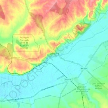
Nom : Carte topographique Coruche, altitude, relief.

Lieu : Coruche, Santarém, 2100-042, Portugal (38.91822 -8.56835 38.99822 -8.48835)

Altitude moyenne : 42 m

Altitude minimum : 10 m

Altitude maximum : 97 m

Autres cartes topographiques

Cliquez sur une carte pour visualiser sa topographie, son altitude et son relief.

Ovelhas

Portugal > Santarém > Coruche > São José da Lamarosa

Ovelhas, São José da Lamarosa, Coruche, Santarém, Portugal

Altitude moyenne : 86 m

Malhada Alta

Portugal > Santarém > Coruche

Malhada Alta, Coruche, Fajarda e Erra, Coruche, Santarém, Portugal

Altitude moyenne : 66 m

Santo Antonino

Portugal > Santarém > Coruche

Santo Antonino, Coruche, Fajarda e Erra, Coruche, Santarém, 2100-042, Portugal

Altitude moyenne : 48 m

Volta do Vale

Portugal > Santarém > Coruche

Volta do Vale, Couço, Coruche, Santarém, Portugal

Altitude moyenne : 56 m

Branca

Portugal > Santarém > Coruche

Branca, Coruche, Santarém, Portugal

Altitude moyenne : 79 m

Biscainho

Portugal > Santarém > Coruche

Biscainho, Coruche, Santarém, Portugal

Altitude moyenne : 55 m

Santana do Mato

Portugal > Santarém > Coruche > Santana do Mato

Santana do Mato, Coruche, Santarém, Portugal

Altitude moyenne : 106 m