
Carte topographique Heads of Ayr Farm Park
Carte interactive
Cliquez sur la carte pour afficher l’altitude.
À propos de cette carte
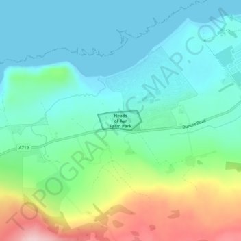
Nom : Carte topographique Heads of Ayr Farm Park, altitude, relief.
Altitude moyenne : 60 m
Altitude minimum : 0 m
Altitude maximum : 221 m
Autres cartes topographiques
Cliquez sur une carte pour visualiser sa topographie, son altitude et son relief.
Dailly
Vereinigtes Königreich > Schottland > South Ayrshire
Dailly, South Ayrshire, Schottland, KA26 9SD, Vereinigtes Königreich
Altitude moyenne : 94 m
Straiton
Vereinigtes Königreich > Schottland > South Ayrshire
Straiton, South Ayrshire, Schottland, KA19 7NF, Vereinigtes Königreich
Altitude moyenne : 186 m
Dunure
Vereinigtes Königreich > Schottland > South Ayrshire
Dunure, South Ayrshire, Schottland, KA7 4LR, Vereinigtes Königreich
Altitude moyenne : 69 m
Troon
Vereinigtes Königreich > Schottland > South Ayrshire
Troon, South Ayrshire, Schottland, KA10 6AZ, Vereinigtes Königreich
Altitude moyenne : 11 m