
Carte topographique Qingyuan City
Carte interactive
Cliquez sur la carte pour afficher l’altitude.
À propos de cette carte
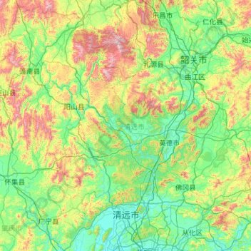
Nom : Carte topographique Qingyuan City, altitude, relief.
Lieu : Qingyuan City, Guangdong Province, China (23.45030 111.92230 25.19432 113.92617)
Altitude moyenne : 349 m
Altitude minimum : 2 m
Altitude maximum : 1 830 m
Qingyuan's administrative area ranges in latitude from 23° 26' 56" to 25° 11' 40" N, and in longitude from 111° 55' 17" to 113° 55' 34" E; its urban area is located just north of the Tropic of Cancer, about 60 km (37 mi) from the urban area of Guangzhou and 200 km (120 mi) from both Hong Kong and Macau. Its area of over 19,000 km2 (7,300 sq mi) accounts for 10.6% of the total provincial area. Qingyuan contains part of the southern Nan Ling, and more than half of the area is mountainous, and elevations increase from southeast to northwest. Bordering prefectures are Guangzhou and Foshan to the southeast, Zhaoqing to the southwest, Shaoguan to the north and northeast, Hezhou (Guangxi) to the west, and Yongzhou and Chenzhou (Hunan) to the north.
Autres cartes topographiques
Cliquez sur une carte pour visualiser sa topographie, son altitude et son relief.
Qiaotou Town
China > Guangdong Province > Dongguan
Qiaotou Town, Dongguan, Guangdong Province, China
Altitude moyenne : 13 m
Luohu District
Luohu District, Shenzhen, Guangdong Province, 518000, China
Altitude moyenne : 74 m
Guangzhou City
Guangzhou City, Guangdong Province, China
Altitude moyenne : 98 m
Yanluo Sub-district
China > Guangdong Province > Bao'an District > Yanluo Sub-district
Yanluo Sub-district, Bao'an District, Shenzhen, Guangdong Province, 518100, China
Altitude moyenne : 40 m
Zengcheng District
Zengcheng District, Guangzhou City, Guangdong Province, China
Altitude moyenne : 106 m
Yuanling Sub-district
China > Guangdong Province > Futian District > Yuanling Sub-district
Yuanling Sub-district, Futian District, Shenzhen, Guangdong Province, 518000, China
Altitude moyenne : 28 m
Hangcheng Sub-district
China > Guangdong Province > Bao'an District > Hangcheng Sub-district
Hangcheng Sub-district, Bao'an District, Shenzhen, Guangdong Province, 518100, China
Altitude moyenne : 21 m