
Carte topographique Châu Đốc
Carte interactive
Cliquez sur la carte pour afficher l’altitude.
À propos de cette carte
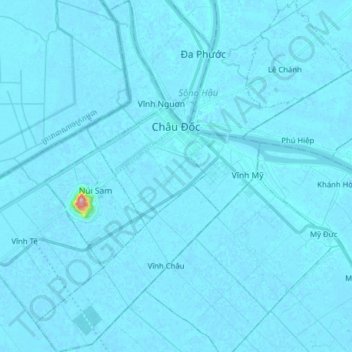
Nom : Carte topographique Châu Đốc, altitude, relief.
Lieu : Châu Đốc, An Giang Province, Vietnam (10.61089 105.02335 10.76522 105.15648)
Altitude moyenne : 3 m
Altitude minimum : -5 m
Altitude maximum : 205 m
Autres cartes topographiques
Cliquez sur une carte pour visualiser sa topographie, son altitude et son relief.
Bình Hòa
Vietnam > An Giang province > Châu Thành District > Xã Bình Hòa
Bình Hòa, Xã Bình Hòa, Châu Thành District, An Giang Province, Vietnam
Altitude moyenne : 3 m
Hoi An
Vietnam > An Giang province > Chợ Mới District
Hoi An, Chợ Mới District, An Giang Province, Vietnam
Altitude moyenne : 5 m
Xã Bình Chánh
Vietnam > An Giang province > Châu Phú District
Xã Bình Chánh, Châu Phú District, An Giang Province, Vietnam
Altitude moyenne : 2 m
Chau Doc
Vietnam > An Giang province > Chau Doc
Chau Doc, Chau Doc City, An Giang Province, 89888, Vietnam
Altitude moyenne : 5 m