
Carte topographique Foston on the Wolds
Carte interactive
Cliquez sur la carte pour afficher l’altitude.
À propos de cette carte
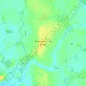
Nom : Carte topographique Foston on the Wolds, altitude, relief.
Altitude moyenne : 8 m
Altitude minimum : -2 m
Altitude maximum : 21 m
Autres cartes topographiques
Cliquez sur une carte pour visualiser sa topographie, son altitude et son relief.
Aldbrough
United Kingdom > England > East Riding of Yorkshire
Aldbrough, East Riding of Yorkshire, England, HU11 4RP, United Kingdom
Altitude moyenne : 11 m
Bridlington
United Kingdom > England > East Riding of Yorkshire
Bridlington, East Riding of Yorkshire, England, United Kingdom
Altitude moyenne : 35 m