
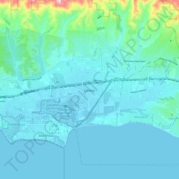
Carte topographique Goleta
Carte interactive
Cliquez sur la carte pour afficher l’altitude.
À propos de cette carte
Nom : Carte topographique Goleta, altitude, relief.
Altitude moyenne : 57 m
Altitude minimum : -1 m
Altitude maximum : 482 m
The Goleta Valley is a coastal plain, approximately three miles (4.8 km) across, between the Santa Ynez Mountains, the principal mountain range of southern Santa Barbara County, and the Pacific Ocean. It consists of Holocene and Pleistocene alluvium, colluvium, estuarine deposits, as well as marine terraces created during interglacial high sea level episodes. The area has been subject to rapid geologic uplift, as evidenced by its coastal bluffs and narrow beaches. Between the flattest part of the Goleta Valley and the ocean is an area of uplift paralleling the shore which includes, from west to east, Isla Vista, Mescalitan Island, More Mesa, and the Hope Ranch Hills. The elevation of this block of land relative to Goleta Valley increases from 40 to 300 feet along this length. The uplift was caused by motion along the More Ranch Fault, one of the most geologically active faults in the area. The More Ranch Fault roughly follows a line along El Colegio Road, through the southern part of the airport, along Atascadero Creek, and then continues east into Santa Barbara as the Mission Ridge Fault Zone. Soils in Goleta are mostly well drained brown fine sandy loam of the Milpitas series.
Autres cartes topographiques
Cliquez sur une carte pour visualiser sa topographie, son altitude et son relief.
Gaffney Park
United States > California > Santa Barbara County > Isla Vista
Gaffney Park, 68 Block, Isla Vista, Santa Barbara County, California, United States
Altitude moyenne : 6 m
Montecito
United States > California > Santa Barbara County
Montecito, Santa Barbara County, CAL Fire Southern Region, California, 93108, United States
Altitude moyenne : 216 m
Vandenberg AFB
United States > California > Santa Barbara County > Vandenberg AFB
Vandenberg AFB, Santa Barbara County, CAL Fire Southern Region, California, 93437, United States
Altitude moyenne : 124 m
Old Town
United States > California > Santa Barbara County > Carpinteria
Old Town, Carpinteria, Santa Barbara County, CAL Fire Southern Region, California, 93013, United States
Altitude moyenne : 26 m
Gaviota
United States > California > Santa Barbara County
Gaviota, Santa Barbara County, CAL Fire Southern Region, California, United States
Altitude moyenne : 82 m
Lions Head
United States > California > Santa Barbara County
Lions Head, Santa Barbara County, CAL Fire Southern Region, California, United States
Altitude moyenne : 65 m
Santa Maria
United States > California > Santa Barbara County
Santa Maria, Santa Barbara County, CAL Fire Southern Region, California, United States
Altitude moyenne : 86 m