Carte topographique Muttersholtz
Carte interactive
Cliquez sur la carte pour afficher l’altitude.
À propos de cette carte
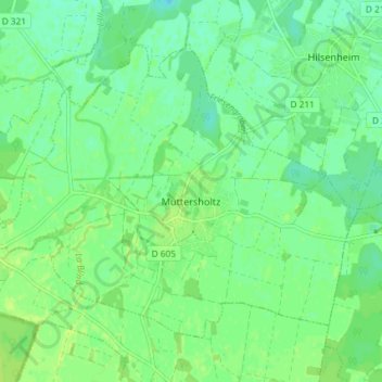
La bourgade est installée à une altitude de 167 m en bordure de la basse terrasse rhénane, directement au contact du ried de l'Ill inondable, qui traverse à l'ouest la commune. La protection par digue est encore visible de Mussig au sud à Kogenheim au nord.
Autres cartes topographiques
Cliquez sur une carte pour visualiser sa topographie, son altitude et son relief.
![Carte topographique Strasbourg, altitude, relief](/pub/maps/relation/7gt6/l45b3/icon.jpg)
Strasbourg
Strasbourg, Bas-Rhin, Grand Est, France métropolitaine, France
Altitude moyenne : 144 m
![Carte topographique Trüdersche, altitude, relief](/pub/maps/relation/96kl/m4dtp/icon.jpg)
Trüdersche
France > Grand Est > Bas-Rhin > Truchtersheim
Trüdersche, Truchtersheim, Saverne, Bas-Rhin, Grand Est, France métropolitaine, 67370, France
Altitude moyenne : 175 m
![Carte topographique Wingersheim, altitude, relief](/pub/maps/relation/fhz4/n6nm2/icon.jpg)
Wingersheim
France > Grand Est > Bas-Rhin > Wingersheim les Quatre Bans
Wingersheim, Wingersheim les Quatre Bans, Saverne, Bas-Rhin, Grand Est, France métropolitaine, 67170, France
Altitude moyenne : 185 m
![Carte topographique Sessenheim, altitude, relief](/pub/maps/relation/2hnx/7t2dt6/icon.jpg)
Sessenheim
Sessenheim, Haguenau-Wissembourg, Bas-Rhin, Grand Est, France métropolitaine, 67770, France
Altitude moyenne : 120 m
![Carte topographique Kirrwiller, altitude, relief](/pub/maps/relation/n5cz/c6wncz/icon.jpg)
Kirrwiller
Kirrwiller, Saverne, Bas-Rhin, Grand Est, France métropolitaine, 67330, France
Altitude moyenne : 213 m
![Carte topographique Ergersheim, altitude, relief](/pub/maps/relation/pzcz/83l1h/icon.jpg)
Ergersheim
Ergersheim, Molsheim, Bas-Rhin, Grand Est, France métropolitaine, 67120, France
Altitude moyenne : 186 m
![Carte topographique Marmoutier, altitude, relief](/pub/maps/relation/hbgp/fbl9kl/icon.jpg)
Marmoutier
Marmoutier, Saverne, Bas-Rhin, Grand Est, France métropolitaine, 67440, France
Altitude moyenne : 246 m
![Carte topographique Betschdorf, altitude, relief](/pub/maps/relation/kw57/v9s551/icon.jpg)
Betschdorf
Betschdorf, Haguenau-Wissembourg, Bas-Rhin, Grand Est, France métropolitaine, 67660, France
Altitude moyenne : 151 m
![Carte topographique Port du Rhin, altitude, relief](/pub/maps/relation/jjtf/s77dnx/icon.jpg)
Port du Rhin
France > Grand Est > Bas-Rhin > Strasbourg
Port du Rhin, Strasbourg, Bas-Rhin, Grand Est, France métropolitaine, 67017, France
Altitude moyenne : 141 m
![Carte topographique Bernardvillé, altitude, relief](/pub/maps/relation/nd3q/hf8ctp/icon.jpg)
Bernardvillé
Bernardvillé, Sélestat-Erstein, Bas-Rhin, Grand Est, France métropolitaine, 67140, France
Altitude moyenne : 360 m
![Carte topographique Heiligenberg, altitude, relief](/pub/maps/relation/6x3l/mb5nh/icon.jpg)
Heiligenberg
Heiligenberg, Molsheim, Bas-Rhin, Grand Est, France métropolitaine, 67190, France
Altitude moyenne : 264 m
![Carte topographique Obersteinbach, altitude, relief](/pub/maps/relation/6btp/4bqgt/icon.jpg)
Obersteinbach
Obersteinbach, Haguenau-Wissembourg, Bas-Rhin, Grand Est, France métropolitaine, 67510, France
Altitude moyenne : 322 m
![Carte topographique Sarrewerden, altitude, relief](/pub/maps/relation/9b14/xmggt/icon.jpg)
Sarrewerden
Sarrewerden, Saverne, Bas-Rhin, Grand Est, France métropolitaine, 67260, France
Altitude moyenne : 274 m
![Carte topographique Hochfelden, altitude, relief](/pub/maps/relation/gn4s/mgkcz/icon.jpg)
Hochfelden
France > Grand Est > Bas-Rhin > Hochfelden
Hochfelden, Saverne, Bas-Rhin, Grand Est, France métropolitaine, 67270, France
Altitude moyenne : 180 m
![Carte topographique Dossenheim-sur-Zinsel, altitude, relief](/pub/maps/relation/bbzs/l28vzs/icon.jpg)
Dossenheim-sur-Zinsel
Dossenheim-sur-Zinsel, Saverne, Bas-Rhin, Grand Est, France métropolitaine, 67330, France
Altitude moyenne : 246 m
![Carte topographique Colroy-la-Roche, altitude, relief](/pub/maps/relation/fxkl/ztht3q/icon.jpg)
Colroy-la-Roche
Colroy-la-Roche, Molsheim, Bas-Rhin, Grand Est, France métropolitaine, 67420, France
Altitude moyenne : 574 m
![Carte topographique Drachenbronn-Birlenbach, altitude, relief](/pub/maps/relation/22rr/8q1j9m/icon.jpg)
Drachenbronn-Birlenbach
Drachenbronn-Birlenbach, Haguenau-Wissembourg, Bas-Rhin, Grand Est, France métropolitaine, 67160, France
Altitude moyenne : 225 m
![Carte topographique Harskirchen, altitude, relief](/pub/maps/relation/jrnx/9dk14/icon.jpg)
Harskirchen
Harskirchen, Saverne, Bas-Rhin, Grand Est, France métropolitaine, 67260, France
Altitude moyenne : 240 m
![Carte topographique Étang de Fleckenstein, altitude, relief](/pub/maps/relation/k2kl/l8mdn/icon.jpg)
Étang de Fleckenstein
France > Grand Est > Bas-Rhin > Lembach
Étang de Fleckenstein, Lembach, Haguenau-Wissembourg, Bas-Rhin, Grand Est, France métropolitaine, 67510, France
Altitude moyenne : 304 m
![Carte topographique Étang Gerig, altitude, relief](/pub/maps/way/1gt/kn7hzs/icon.jpg)
Étang Gerig
France > Grand Est > Bas-Rhin > Ostwald
Étang Gerig, Ostwald, Strasbourg, Bas-Rhin, Grand Est, France métropolitaine, 67540, France
Altitude moyenne : 142 m
![Carte topographique Saint-Jean-Saverne, altitude, relief](/pub/maps/relation/s6m2/19cjm2/icon.jpg)
Saint-Jean-Saverne
Saint-Jean-Saverne, Saverne, Bas-Rhin, Grand Est, France métropolitaine, 67700, France
Altitude moyenne : 272 m
![Carte topographique Eckwersheim, altitude, relief](/pub/maps/relation/75b3/wxm5k/icon.jpg)
Eckwersheim
Eckwersheim, Strasbourg, Bas-Rhin, Grand Est, France métropolitaine, 67550, France
Altitude moyenne : 156 m
![Carte topographique 67117, altitude, relief](/pub/maps/relation/14s/2fc7t6/icon.jpg)
67117
France > Grand Est > Bas-Rhin > Hurtigheim
67117, Hurtigheim, Saverne, Bas-Rhin, Grand Est, France métropolitaine, France
Altitude moyenne : 175 m
![Carte topographique Zinswiller, altitude, relief](/pub/maps/relation/18/3cq918/icon.jpg)
Zinswiller
Zinswiller, Haguenau-Wissembourg, Bas-Rhin, Grand Est, France métropolitaine, 67110, France
Altitude moyenne : 240 m
![Carte topographique Niederhaslach, altitude, relief](/pub/maps/relation/fls8/dhdzs/icon.jpg)
Niederhaslach
Niederhaslach, Molsheim, Bas-Rhin, Grand Est, France métropolitaine, 67280, France
Altitude moyenne : 282 m
![Carte topographique Natzwiller, altitude, relief](/pub/maps/relation/6stf/24srrr/icon.jpg)
Natzwiller
Natzwiller, Molsheim, Bas-Rhin, Grand Est, France métropolitaine, 67130, France
Altitude moyenne : 705 m
![Carte topographique Kaltenhouse, altitude, relief](/pub/maps/relation/6n4s/m6kcz/icon.jpg)
Kaltenhouse
Kaltenhouse, Haguenau-Wissembourg, Bas-Rhin, Grand Est, France métropolitaine, 67240, France
Altitude moyenne : 142 m
![Carte topographique Ernolsheim-Bruche, altitude, relief](/pub/maps/relation/d99m/4hgmt/icon.jpg)
Ernolsheim-Bruche
Ernolsheim-Bruche, Molsheim, Bas-Rhin, Grand Est, France métropolitaine, 67120, France
Altitude moyenne : 173 m
![Carte topographique Dieffenthal, altitude, relief](/pub/maps/relation/sztp/492gt/icon.jpg)
Dieffenthal
Dieffenthal, Sélestat-Erstein, Bas-Rhin, Grand Est, France métropolitaine, 67650, France
Altitude moyenne : 241 m
![Carte topographique Bellefosse, altitude, relief](/pub/maps/relation/gj3l/s97cb3/icon.jpg)
Bellefosse
Bellefosse, Molsheim, Bas-Rhin, Grand Est, France métropolitaine, 67130, France
Altitude moyenne : 716 m