
Faire un don
Équipez-vous pour votre prochaine aventure :
En tant que Partenaire Amazon, ce site perçoit une commission sur les achats éligibles sans surcoût pour vous.
Carte topographique North Cape
Cliquez sur la carte pour afficher l’altitude.
Faire un don
Équipez-vous pour votre prochaine aventure :
En tant que Partenaire Amazon, ce site perçoit une commission sur les achats éligibles sans surcoût pour vous.
À propos de cette carte
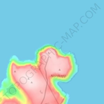
Nom : Carte topographique North Cape, altitude, relief.
Lieu : North Cape, Nordkapp, Finnmark, Norway (71.14995 25.76589 71.18995 25.80589)
Altitude moyenne : 64 m
Altitude minimum : -15 m
Altitude maximum : 324 m
Faire un don
Équipez-vous pour votre prochaine aventure :
En tant que Partenaire Amazon, ce site perçoit une commission sur les achats éligibles sans surcoût pour vous.
Autres cartes topographiques
Cliquez sur une carte pour visualiser sa topographie, son altitude et son relief.
Alta
The town of Alta and most of the municipality is located just below the 70th latitude and is closer to the North Pole than it is to much of Central Europe and the British Isles. The town is the northernmost settlement of urban significance in the European Economic Area, with municipalities north of Alta being…
Altitude moyenne : 372 m
Faire un don
Équipez-vous pour votre prochaine aventure :
En tant que Partenaire Amazon, ce site perçoit une commission sur les achats éligibles sans surcoût pour vous.
Faire un don
Équipez-vous pour votre prochaine aventure :
En tant que Partenaire Amazon, ce site perçoit une commission sur les achats éligibles sans surcoût pour vous.
Alta
The town of Alta and most of the municipality is located just below the 70th latitude and is closer to the North Pole than it is to much of Central Europe and the British Isles. The town is the northernmost settlement of urban significance in the European Economic Area, with municipalities north of Alta being…
Altitude moyenne : 372 m