
Carte topographique Spital am Pyhrn
Carte interactive
Cliquez sur la carte pour afficher l’altitude.
À propos de cette carte
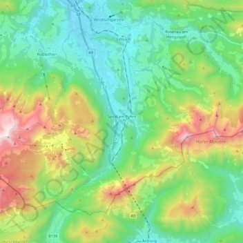
Nom : Carte topographique Spital am Pyhrn, altitude, relief.
Lieu : Spital am Pyhrn, Bezirk Kirchdorf, 4582, Österreich (47.60636 14.22310 47.71680 14.43601)
Altitude moyenne : 1 106 m
Altitude minimum : 571 m
Altitude maximum : 2 367 m
Spital am Pyhrn liegt auf 640 m Seehöhe im Traunviertel. Die Ausdehnung beträgt von Nord nach Süd 16 und von West nach Ost 12,3 Kilometer. Die Gesamtfläche der Gemeinde umfasst 108,89 Quadratkilometer. Davon sind 63 Prozent bewaldet und 15 Prozent werden landwirtschaftlich genutzt.
Autres cartes topographiques
Cliquez sur une carte pour visualiser sa topographie, son altitude et son relief.
Pettenbach
Pettenbach, Bezirk Kirchdorf, 4643, Österreich
Altitude moyenne : 518 m
Wartberg an der Krems
Wartberg an der Krems, Bezirk Kirchdorf, 4552, Österreich
Altitude moyenne : 462 m
Edlbach
Edlbach, Bezirk Kirchdorf, 4580, Österreich
Altitude moyenne : 675 m
Windischgarsten
Windischgarsten, Bezirk Kirchdorf, 4580, Österreich
Altitude moyenne : 660 m
Großer Priel
Österreich > Bezirk Kirchdorf > Hinterstoder
Großer Priel, Hinterstoder, Bezirk Kirchdorf, 4573, Österreich
Altitude moyenne : 1 919 m
Steinbach an der Steyr
Steinbach an der Steyr, Bezirk Kirchdorf, 4596, Österreich
Altitude moyenne : 543 m