
Faire un don
Équipez-vous pour votre prochaine aventure :
En tant que Partenaire Amazon, ce site perçoit une commission sur les achats éligibles sans surcoût pour vous.
Carte topographique Surquillo
Cliquez sur la carte pour afficher l’altitude.
Faire un don
Équipez-vous pour votre prochaine aventure :
En tant que Partenaire Amazon, ce site perçoit une commission sur les achats éligibles sans surcoût pour vous.
Surquillo
Since the beginning of the 2000s and the beginning of the 2010s, and to a greater extent today, there has been a considerable real estate boom within Surquillo, in which many residential real estate companies have invested in new residential building projects in several points of the district due to the modification of the urban and building parameters in the district. For this reason, many high-altitude residential buildings have been built in different points such as the areas adjacent to Principal and Andrés Aramburú avenues, as well as parts of urbanizations such as La Calera, Barrio Médico, Los Sauces, and recently along the route of Tomás Marsano Avenue on the border with the Miraflores district and sections of Angamos Avenue. This also brought about the appreciation of house prices in various parts of the district.
Faire un don
Équipez-vous pour votre prochaine aventure :
En tant que Partenaire Amazon, ce site perçoit une commission sur les achats éligibles sans surcoût pour vous.
À propos de cette carte
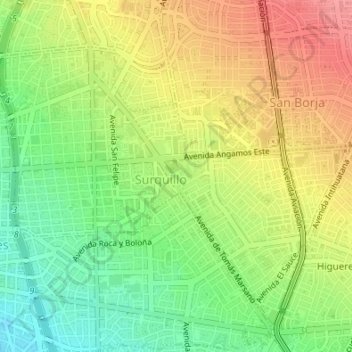
Nom : Carte topographique Surquillo, altitude, relief.
Altitude moyenne : 118 m
Altitude minimum : 78 m
Altitude maximum : 163 m
Faire un don
Équipez-vous pour votre prochaine aventure :
En tant que Partenaire Amazon, ce site perçoit une commission sur les achats éligibles sans surcoût pour vous.
Autres cartes topographiques
Cliquez sur une carte pour visualiser sa topographie, son altitude et son relief.