
Carte topographique Rügland
Carte interactive
Cliquez sur la carte pour afficher l’altitude.
À propos de cette carte
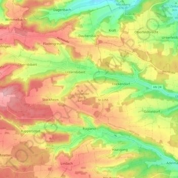
Nom : Carte topographique Rügland, altitude, relief.
Altitude moyenne : 422 m
Altitude minimum : 338 m
Altitude maximum : 494 m
Rügland liegt im Naturpark Frankenhöhe.
Autres cartes topographiques
Cliquez sur une carte pour visualiser sa topographie, son altitude et son relief.
Ornbau
Deutschland > Bayern > Landkreis Ansbach
Ornbau, Triesdorf (VGem), Landkreis Ansbach, Bayern, 91737, Deutschland
Altitude moyenne : 423 m
Dauersmühle
Deutschland > Bayern > Landkreis Ansbach > Buhlsbach
Dauersmühle, Buhlsbach, Lehrberg, Landkreis Ansbach, Bayern, 91611, Deutschland
Altitude moyenne : 456 m
Insingen
Deutschland > Bayern > Landkreis Ansbach
Insingen, Rothenburg ob der Tauber (VGem), Landkreis Ansbach, Bayern, 91610, Deutschland
Altitude moyenne : 419 m
Rothenburg ob der Tauber
Deutschland > Bayern > Landkreis Ansbach
Rothenburg ob der Tauber, Landkreis Ansbach, Bayern, 91541, Deutschland
Altitude moyenne : 419 m
Wilburgstetten
Deutschland > Bayern > Landkreis Ansbach
Wilburgstetten, Wilburgstetten (VGem), Landkreis Ansbach, Bayern, 91634, Deutschland
Altitude moyenne : 472 m
Schopfloch
Deutschland > Bayern > Landkreis Ansbach
Schopfloch, Landkreis Ansbach, Bayern, 91626, Deutschland
Altitude moyenne : 473 m
Schönbronn
Deutschland > Bayern > Landkreis Ansbach
Schönbronn, Buch am Wald, Schillingsfürst (VGem), Landkreis Ansbach, Bayern, 91592, Deutschland
Altitude moyenne : 468 m