
Carte topographique Baotou City
Carte interactive
Cliquez sur la carte pour afficher l’altitude.
À propos de cette carte
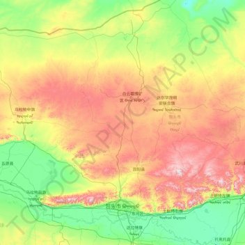
Nom : Carte topographique Baotou City, altitude, relief.
Lieu : Baotou City, Inner Mongolia, 014000, China (40.24600 109.26244 42.73599 111.43633)
Altitude moyenne : 1 316 m
Altitude minimum : 960 m
Altitude maximum : 2 294 m
Baotou features a cold semi-arid climate (Köppen BSk), marked by long, cold and very dry winters, hot, somewhat humid summers, and strong winds, especially in spring. Temperatures often fall below −15 °C (5 °F) in winter and rise above 30 °C (86 °F) in summer. The annual precipitation is approximately 300 millimetres (11.8 in), with more than half of it falling in July and August alone. Due to the aridity and elevation, temperature differences between day and night can be large, especially in spring. In 2002, there were 12 instances of dust storms.