Carte topographique Murphys
Cliquez sur la carte pour afficher l’altitude.
Murphys
"MURPHY'S CAMP is a curious old mining-town in Calaveras County, at an elevation of 2,400 feet (730 m) above the sea, situated like a nest in the center of a rough, gravelly region, rich in gold. Granites, slates, lavas, limestone, iron ores, quartz veins, auriferous gravels, remnants of dead fire-rivers and dead water-rivers are developed here side by side within a radius of a few miles, and placed invitingly open before the student like a book, while the people and the region beyond the camp furnish mines of study of never-failing interest and variety."
À propos de cette carte
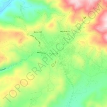
Nom : Carte topographique Murphys, altitude, relief.
Altitude moyenne : 702 m
Altitude minimum : 535 m
Altitude maximum : 913 m
Autres cartes topographiques
Cliquez sur une carte pour visualiser sa topographie, son altitude et son relief.
Dorrington
United States > California > Calaveras County
According to the United States Census Bureau, the CDP has a total area of 3.7 square miles (9.6 km2), 99.86% of it land. The elevation is 4,800 feet ASL.
Altitude moyenne : 1 464 m
Angels
United States > California > Calaveras County
Angels Camp, also known as City of Angels and formerly Angel's Camp, Angels, Angels City, Carson's Creek and Clearlake, is the only incorporated city in Calaveras County, California, United States. The population was 3,836 at the 2010 census, up from 3,004 at the 2000 census. It lies at an elevation of 1378…
Altitude moyenne : 459 m


Murphys
United States > California > Calaveras County > Murphys
"MURPHY'S CAMP is a curious old mining-town in Calaveras County, at an elevation of 2,400 feet (730 m) above the sea, situated like a nest in the center of a rough, gravelly region, rich in gold. Granites, slates, lavas, limestone, iron ores, quartz veins, auriferous gravels, remnants of dead fire-rivers and…
Altitude moyenne : 717 m
Murphys
United States > California > Calaveras County > Murphys
MURPHY'S CAMP is a curious old mining-town in Calaveras County, at an elevation of 2,400 feet (730 m) above the sea, situated like a nest in the center of a rough, gravelly region, rich in gold. Granites, slates, lavas, limestone, iron ores, quartz veins, auriferous gravels, remnants of dead fire-rivers and…
Altitude moyenne : 717 m

Paloma
United States > California > Calaveras County > Paloma
Paloma (Spanish for "dove"; formerly, Fosteria and Frenchman's Ranch) is an unincorporated community in Calaveras County, California. It lies at an elevation of 1362 feet (415 m) and is located at 38°15′34″N 120°45′48″W / 38.25944°N 120.76333°W / 38.25944; -120.76333. The community is in…
Altitude moyenne : 418 m
Angels Camp
United States > California > Calaveras County
Angels Camp, also known as City of Angels and formerly Angel's Camp, Angels, Angels City, Carson's Creek and Clearlake, is the only incorporated city in Calaveras County, California, United States. The population was 3,836 at the 2010 census, up from 3,004 at the 2000 census. It lies at an elevation of 1378…
Altitude moyenne : 461 m

Dorrington
United States > California > Calaveras County
According to the United States Census Bureau, the CDP has a total area of 4.1 square miles (11 km2), 99.88% of it land. The elevation is 4,800 feet ASL.
Altitude moyenne : 1 466 m
Angels
United States > California > Calaveras County
Angels Camp (formerly Angel's Camp, Angels, Angels City, Carson's Creek and Clearlake), is the only incorporated city in Calaveras County, California, United States. The population was 3,667 at the 2020 census. It lies at an elevation of 1381 feet (421 m).
Altitude moyenne : 459 m


Calaveras Big Trees State Park
United States > California > Calaveras County
Altitude moyenne : 1 375 m
Dorrington
United States > California > Calaveras County
According to the United States Census Bureau, the CDP has a total area of 3.7 square miles (9.6 km2), 99.86% of it land. The elevation is 4,800 feet ASL.
Altitude moyenne : 1 464 m