
Faire un don
Équipez-vous pour votre prochaine aventure :
En tant que Partenaire Amazon, ce site perçoit une commission sur les achats éligibles sans surcoût pour vous.
Carte topographique Fort Garland
Cliquez sur la carte pour afficher l’altitude.
Faire un don
Équipez-vous pour votre prochaine aventure :
En tant que Partenaire Amazon, ce site perçoit une commission sur les achats éligibles sans surcoût pour vous.
Fort Garland
Fort Garland is located at an elevation of 7,936 ft (2,419 m) in northern Costilla County. Fort Garland is at the crossroads of U.S. Route 160 and Colorado State Highway 159, which leads south towards Taos and Santa Fe, New Mexico. The town of Blanca is 4 miles (6.4 km) west on U.S. Route 160. Walsenburg is 47 miles (76 km) to the east, across the Sangre de Cristo Range.
Faire un don
Équipez-vous pour votre prochaine aventure :
En tant que Partenaire Amazon, ce site perçoit une commission sur les achats éligibles sans surcoût pour vous.
À propos de cette carte
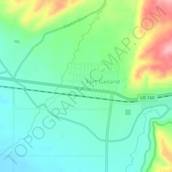
Nom : Carte topographique Fort Garland, altitude, relief.
Lieu : Fort Garland, Costilla County, Colorado, United States (37.42461 -105.44552 37.43178 -105.43032)
Altitude moyenne : 2 427 m
Altitude minimum : 2 386 m
Altitude maximum : 2 520 m
Faire un don
Équipez-vous pour votre prochaine aventure :
En tant que Partenaire Amazon, ce site perçoit une commission sur les achats éligibles sans surcoût pour vous.
Autres cartes topographiques
Cliquez sur une carte pour visualiser sa topographie, son altitude et son relief.
Fort Garland
United States > Colorado > Costilla County > Fort Garland
Fort Garland is located at an elevation of 7,936 ft (2,419 m) in northern Costilla County. Fort Garland is at the crossroads of U.S. Route 160 and Colorado State Highway 159, which leads south towards Taos and Santa Fe, New Mexico. The town of Blanca is 4 miles (6.4 km) west on U.S. Route 160. Walsenburg is 47…
Altitude moyenne : 2 427 m