
Carte topographique Thompson Falls
Carte interactive
Cliquez sur la carte pour afficher l’altitude.
À propos de cette carte
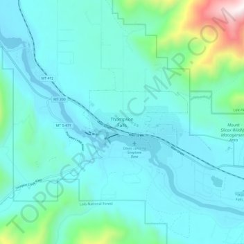
Nom : Carte topographique Thompson Falls, altitude, relief.
Altitude moyenne : 897 m
Altitude minimum : 709 m
Altitude maximum : 2 032 m
Thompson Falls is located at 47°35′48″N 115°20′37″W / 47.59667°N 115.34361°W / 47.59667; -115.34361 (47.596587, -115.343730) in the Clark Fork Valley at an elevation of 2,419 feet (737 m).