
Faire un don
Équipez-vous pour votre prochaine aventure :
En tant que Partenaire Amazon, ce site perçoit une commission sur les achats éligibles sans surcoût pour vous.
Carte topographique Pelham
Cliquez sur la carte pour afficher l’altitude.
Faire un don
Équipez-vous pour votre prochaine aventure :
En tant que Partenaire Amazon, ce site perçoit une commission sur les achats éligibles sans surcoût pour vous.
Pelham
From the top of the Fonthill Kame Delta hill, a unique topographical feature (Ontario Geological Society 1970) and ANSI protected site (Area of Natural Scientific Interest - ANSI) on a clear day it is possible to see Toronto, Hamilton and western New York state. At one time, a ski tow was installed on the north side of the Kame Delta Hill on what is now Lookout Point Golf and Country Club, but it was a commercial failure and no longer operates.
Faire un don
Équipez-vous pour votre prochaine aventure :
En tant que Partenaire Amazon, ce site perçoit une commission sur les achats éligibles sans surcoût pour vous.
À propos de cette carte
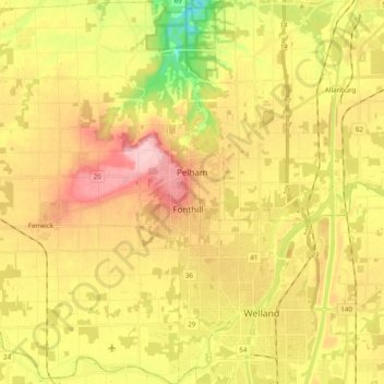
Nom : Carte topographique Pelham, altitude, relief.
Lieu : Pelham, Niagara Region, Golden Horseshoe, Ontario, Canada (42.96566 -79.39016 43.10865 -79.26739)
Altitude moyenne : 183 m
Altitude minimum : 94 m
Altitude maximum : 260 m
Faire un don
Équipez-vous pour votre prochaine aventure :
En tant que Partenaire Amazon, ce site perçoit une commission sur les achats éligibles sans surcoût pour vous.