
Faire un don
Équipez-vous pour votre prochaine aventure :
En tant que Partenaire Amazon, ce site perçoit une commission sur les achats éligibles sans surcoût pour vous.
Carte topographique Amarnath Cave Temple
Cliquez sur la carte pour afficher l’altitude.
Faire un don
Équipez-vous pour votre prochaine aventure :
En tant que Partenaire Amazon, ce site perçoit une commission sur les achats éligibles sans surcoût pour vous.
Amarnath Cave Temple
Amarnath Temple is a Hindu shrine located in the Pahalgam tehsil of the Anantnag district of Jammu and Kashmir, India. It is a cave situated at an altitude of 3,888 m (12,756 ft), about 168 km from Anantnag city, the district headquarters, 141 km (88 mi) from Srinagar, the summer capital of Jammu and Kashmir, reached through either Sonamarg or Pahalgam. It is an important shrine in Hinduism.
Faire un don
Équipez-vous pour votre prochaine aventure :
En tant que Partenaire Amazon, ce site perçoit une commission sur les achats éligibles sans surcoût pour vous.
À propos de cette carte
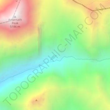
Nom : Carte topographique Amarnath Cave Temple, altitude, relief.
Altitude moyenne : 4 325 m
Altitude minimum : 3 719 m
Altitude maximum : 5 200 m
Faire un don
Équipez-vous pour votre prochaine aventure :
En tant que Partenaire Amazon, ce site perçoit une commission sur les achats éligibles sans surcoût pour vous.