
Carte topographique Tecopa
Cliquez sur la carte pour afficher l’altitude.
Tecopa
Tecopa (formerly Brownsville[4]) is a census-designated place (CDP) in the Mojave Desert, in Inyo County, California, United States. Tecopa is located 9 miles (14 km) south-southeast of Shoshone,[4] at an elevation of 1,339 feet (408 m).[3] The population was 150 at the 2010 census, up from 99 at the 2000 census.
À propos de cette carte
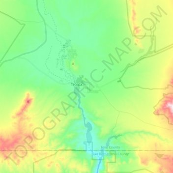
Nom : Carte topographique Tecopa, altitude, relief.
Lieu : Tecopa, Inyo County, California, United States (35.79330 -116.28677 35.89955 -116.10947)
Altitude moyenne : 508 m
Altitude minimum : 308 m
Altitude maximum : 926 m
Autres cartes topographiques
Cliquez sur une carte pour visualiser sa topographie, son altitude et son relief.