
Carte topographique Ungaran
Cliquez sur la carte pour afficher l’altitude.
Ungaran
Ungaran (Dutch: Oengaran) is a town and adjacent areas in Central Java Province of Indonesia. The town serves as the administrative centre of the Semarang Regency in that province. Ungaran is located at -7° 8' 17", 110° 24' 18" at an elevation of 319 metres. It encompasses two districts (kecamatan) within the Regency - Ungaran Barat (West Ungaran) covering 35.96 km2 with a population of 82,815 in 2024, and Ungaran Timur (East Ungaran) covering 37.99 km2 with a population of 83,610 in 2024.
À propos de cette carte
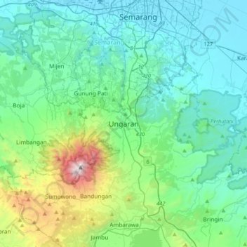
Nom : Carte topographique Ungaran, altitude, relief.
Altitude moyenne : 399 m
Altitude minimum : 78 m
Altitude maximum : 1 558 m
Autres cartes topographiques
Cliquez sur une carte pour visualiser sa topographie, son altitude et son relief.
Alun-Alun Ambarawa
Indonesia > Central Java > Kabupaten Semarang > Tambakboyo > Katang
Altitude moyenne : 499 m