
Carte topographique Konkordiahütte
Carte interactive
Cliquez sur la carte pour afficher l’altitude.
À propos de cette carte
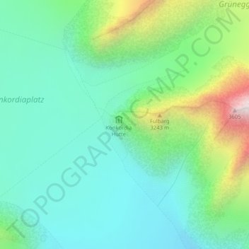
Nom : Carte topographique Konkordiahütte, altitude, relief.
Lieu : Konkordiahütte, Fieschertal, Goms, Wallis, Schweiz (46.48988 8.04418 46.50988 8.06418)
Altitude moyenne : 2 839 m
Altitude minimum : 2 545 m
Altitude maximum : 3 654 m
Autres cartes topographiques
Cliquez sur une carte pour visualiser sa topographie, son altitude et son relief.
Grosser Aletschgletscher
Schweiz > Wallis > Goms > Fieschertal
Grosser Aletschgletscher, Fieschertal, Goms, Wallis, Schweiz
Altitude moyenne : 2 532 m
Mönch
Schweiz > Wallis > Goms > Fieschertal
Mönch, Fieschertal, Goms, Verwaltungsregion Oberland, Wallis, 3801, Schweiz
Altitude moyenne : 3 392 m
Kranzberg
Schweiz > Wallis > Goms > Fieschertal
Kranzberg, Fieschertal, Goms, Wallis, 3801, Schweiz
Altitude moyenne : 3 403 m
Finsteraarhorn
Schweiz > Wallis > Goms > Fieschertal
Finsteraarhorn, Fieschertal, Goms, Wallis, Schweiz
Altitude moyenne : 3 420 m