
Carte topographique Västerås
Carte interactive
Cliquez sur la carte pour afficher l’altitude.
À propos de cette carte
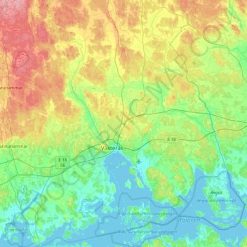
Nom : Carte topographique Västerås, altitude, relief.
Lieu : Västerås, Contea di Västmanland, Svealand, Svezia (59.45233 16.23463 59.84598 16.96595)
Altitude moyenne : 33 m
Altitude minimum : -4 m
Altitude maximum : 116 m
Autres cartes topographiques
Cliquez sur une carte pour visualiser sa topographie, son altitude et son relief.
Västerås
Svezia > Contea di Västmanland > Västerås
Västerås, Västerås kommun, Contea di Västmanland, Svealand, 721 01, Svezia
Altitude moyenne : 28 m
Contea di Västmanland
Svezia > Contea di Västmanland
Contea di Västmanland, Svealand, Svezia
Altitude moyenne : 75 m