
Faire un don
Équipez-vous pour votre prochaine aventure :
En tant que Partenaire Amazon, ce site perçoit une commission sur les achats éligibles sans surcoût pour vous.
Carte topographique FELDA Gedangsa
Cliquez sur la carte pour afficher l’altitude.
Faire un don
Équipez-vous pour votre prochaine aventure :
En tant que Partenaire Amazon, ce site perçoit une commission sur les achats éligibles sans surcoût pour vous.
À propos de cette carte
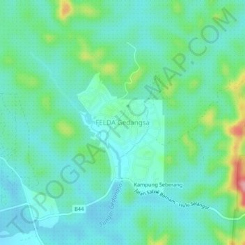
Nom : Carte topographique FELDA Gedangsa, altitude, relief.
Lieu : FELDA Gedangsa, Hulu Selangor, 44020, Malaysia (3.71934 101.36372 3.75934 101.40372)
Altitude moyenne : 41 m
Altitude minimum : 10 m
Altitude maximum : 143 m
Faire un don
Équipez-vous pour votre prochaine aventure :
En tant que Partenaire Amazon, ce site perçoit une commission sur les achats éligibles sans surcoût pour vous.
Autres cartes topographiques
Cliquez sur une carte pour visualiser sa topographie, son altitude et son relief.
Faire un don
Équipez-vous pour votre prochaine aventure :
En tant que Partenaire Amazon, ce site perçoit une commission sur les achats éligibles sans surcoût pour vous.
Kelantan River
Malaysia > Kelantan > Kampung Paloh
The river's tributaries rise in the forested mountains in the Gua Musang region in southern Kelantan, where many Orang Asli tribes live. The area is known for its karst topography, dotted with mogotes with numerous caves beneath them. Some cave systems along the Nenggiri River, the river's left tributary, show…
Altitude moyenne : 71 m
Faire un don
Équipez-vous pour votre prochaine aventure :
En tant que Partenaire Amazon, ce site perçoit une commission sur les achats éligibles sans surcoût pour vous.
Sabah
The jungles of Sabah host a diverse array of plant and animal species. Most of Sabah's biodiversity is located in the forest reserve areas, which formed half of its total landmass of 7.34 million hectares. Its forest reserve are part of the 20 million hectares equatorial rainforests demarcated under the "Heart…
Altitude moyenne : 115 m
Perak
In 1959, a British artillery officer stationed at an inland army base during the Malayan Emergency discovered the Tambun rock art, identified by archaeologists as the largest rock art site in the Malay Peninsula. Most of the paintings are located high above the cave floor, at an elevation of 6–10 metres…
Altitude moyenne : 251 m
Faire un don
Équipez-vous pour votre prochaine aventure :
En tant que Partenaire Amazon, ce site perçoit une commission sur les achats éligibles sans surcoût pour vous.
Faire un don
Équipez-vous pour votre prochaine aventure :
En tant que Partenaire Amazon, ce site perçoit une commission sur les achats éligibles sans surcoût pour vous.
Jelebu
Amongst the seven districts of Negeri Sembilan, Jelebu is the most mountainous topographically as the Titiwangsa Mountains, the longest mountain range in Malaysia, transverses through the district. As a result, most of its terrain are dominated by forested undulating hills and mountain peaks. The Titiwangsa…
Altitude moyenne : 307 m
Faire un don
Équipez-vous pour votre prochaine aventure :
En tant que Partenaire Amazon, ce site perçoit une commission sur les achats éligibles sans surcoût pour vous.
Faire un don
Équipez-vous pour votre prochaine aventure :
En tant que Partenaire Amazon, ce site perçoit une commission sur les achats éligibles sans surcoût pour vous.
Faire un don
Équipez-vous pour votre prochaine aventure :
En tant que Partenaire Amazon, ce site perçoit une commission sur les achats éligibles sans surcoût pour vous.
Selayang Municipal Council
Malaysia > Selangor > Selayang Municipal Council
Given its varied topography pattern and close proximity to the Titiwangsa Mountains (Banjaran Titiwangsa), Selayang is a mix of urban and countryside sceneries. Its premier natural attraction, which is well-known across the country, is the Forest Research Institute Malaysia (FRIM), also known as FRIM Kepong.…
Altitude moyenne : 236 m
Faire un don
Équipez-vous pour votre prochaine aventure :
En tant que Partenaire Amazon, ce site perçoit une commission sur les achats éligibles sans surcoût pour vous.
Faire un don
Équipez-vous pour votre prochaine aventure :
En tant que Partenaire Amazon, ce site perçoit une commission sur les achats éligibles sans surcoût pour vous.
Faire un don
Équipez-vous pour votre prochaine aventure :
En tant que Partenaire Amazon, ce site perçoit une commission sur les achats éligibles sans surcoût pour vous.
Faire un don
Équipez-vous pour votre prochaine aventure :
En tant que Partenaire Amazon, ce site perçoit une commission sur les achats éligibles sans surcoût pour vous.