
Carte topographique Abucay
Carte interactive
Cliquez sur la carte pour afficher l’altitude.
À propos de cette carte
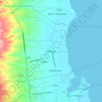
Nom : Carte topographique Abucay, altitude, relief.
Lieu : Abucay, Bataan, Central Luzon, 2114, Philippines (14.68131 120.49487 14.76131 120.57487)
Altitude moyenne : 22 m
Altitude minimum : 0 m
Altitude maximum : 129 m
Topography of Abucay varies from the mountainous terrain of Mount Natib caldera in the west to the coastal areas of the province along the shore of Manila Bay. Six rivers with a combined length of 37 kilometres (23 mi) originate from the mountain flowing in the west-to-east direction.