
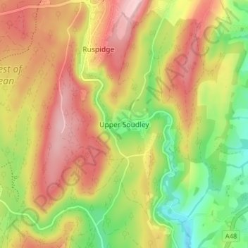
Carte topographique Upper Soudley
Carte interactive
Cliquez sur la carte pour afficher l’altitude.
À propos de cette carte
Nom : Carte topographique Upper Soudley, altitude, relief.
Altitude moyenne : 138 m
Altitude minimum : 34 m
Altitude maximum : 234 m
Autres cartes topographiques
Cliquez sur une carte pour visualiser sa topographie, son altitude et son relief.
Tidenham Chase
United Kingdom > England > Gloucestershire > Forest of Dean
Tidenham Chase, Forest of Dean, Gloucestershire, England, NP16 7JW, United Kingdom
Altitude moyenne : 112 m
Fossil Beach
United Kingdom > England > Gloucestershire > Forest of Dean > Sedbury
Fossil Beach, Tidenham, Sedbury, Forest of Dean, Gloucestershire, England, NP16 7FD, United Kingdom
Altitude moyenne : 14 m
Strand
United Kingdom > England > Gloucestershire > Forest of Dean > Westbury-on-Severn
Strand, Westbury-on-Severn, Forest of Dean, Gloucestershire, England, GL14 1PG, United Kingdom
Altitude moyenne : 14 m
The Noose
United Kingdom > England > Gloucestershire > Forest of Dean > Awre
The Noose, Awre, Forest of Dean, Gloucestershire, South West England, England, GL14 1, United Kingdom
Altitude moyenne : 5 m