
Carte topographique Zwartsluis
Carte interactive
Cliquez sur la carte pour afficher l’altitude.
À propos de cette carte
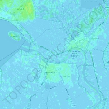
Nom : Carte topographique Zwartsluis, altitude, relief.
Lieu : Zwartsluis, Zwartewaterland, Overijssel, Niederlande (52.60008 6.01254 52.66794 6.12027)
Altitude moyenne : 0 m
Altitude minimum : -5 m
Altitude maximum : 9 m
Autres cartes topographiques
Cliquez sur une carte pour visualiser sa topographie, son altitude et son relief.
Mastenbroek
Niederlande > Overijssel > Zwartewaterland
Mastenbroek, Zwartewaterland, Overijssel, Niederlande
Altitude moyenne : 0 m
Zwartewaterland
Niederlande > Overijssel > Zwartewaterland
Zwartewaterland, Overijssel, Niederlande
Altitude moyenne : 0 m