
Carte topographique Castro Verde
Carte interactive
Cliquez sur la carte pour afficher l’altitude.
À propos de cette carte
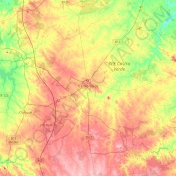
Nom : Carte topographique Castro Verde, altitude, relief.
Lieu : Castro Verde, Beja, Portugal (37.56124 -8.24654 37.82735 -7.84902)
Altitude moyenne : 206 m
Altitude minimum : 101 m
Altitude maximum : 306 m
The Castro Verde area is made up of extensive areas of rolling hills, geomorphological structures referred to as a peneplains, which vary in altitude from 300 to 900 ft (100–300 m.) above sea level. The area has planar relief, with a medium altitude of approximately 200 metres; the lowest point is about 110 metres, in the civil parish of São Marcos da Atabueira, near the Ribeira de Cobres (in northeast frontier with the municipality of Beja). The highest point, at 299 metres, is located at a geodesic marker (Urza) on the Cerro da Bandeira, within the civil parish of Castro Verde. Slopes in this area are between 0-2% grade, although pronounced (15%) along the ravines of Cobres and Maria Delgada, and the vicinity of Ribeira de Oeiras (near the border with Almodôvar). In addition to these rivers, the municipality is crossed by other ribeiras (English: ravines or rivers): Ribeira de Alvacar, Ribeira da Fontinha, Ribeira de Terges, Ribeira da Chada, Ribeira da Sete and Ribeira da Gata.
Autres cartes topographiques
Cliquez sur une carte pour visualiser sa topographie, son altitude et son relief.
Ribeira dos Lameiros
Ribeira dos Lameiros, São Luís, Odemira, Beja, Portugal
Altitude moyenne : 107 m
Corte Gafo de Cima
Portugal > Beja > Mértola > Corte Gafo de Cima
Corte Gafo de Cima, Mértola, Beja, 7750-308, Portugal
Altitude moyenne : 166 m