
Carte topographique Aue
Cliquez sur la carte pour afficher l’altitude.
À propos de cette carte
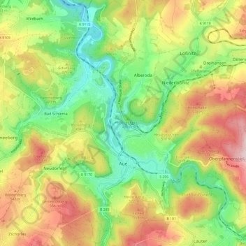
Nom : Carte topographique Aue, altitude, relief.
Lieu : Aue, Aue-Bad Schlema, Erzgebirgskreis, Saxony, 08280, Germany (50.56151 12.65549 50.63743 12.73984)
Altitude moyenne : 465 m
Altitude minimum : 315 m
Altitude maximum : 657 m
Autres cartes topographiques
Cliquez sur une carte pour visualiser sa topographie, son altitude et son relief.
Markersbach
Germany > Saxony > Erzgebirgskreis
In 1889, Markersbach was connected to the railway line from Schwarzenberg to Annaberg, which was closed to passenger transport on 27 September 1997. The station lay in Mittweida’s municipal area and the platform signs read Mittweida-Markersbach. To overcome the great elevation differential, the railway's…
Altitude moyenne : 600 m