
Carte topographique Sighnaghi
Carte interactive
Cliquez sur la carte pour afficher l’altitude.
Sighnaghi
The town has an area of 2.978 ha with 24.3% being residential. Signagi is approximately 113 km southeast of Tbilisi, the capital of Georgia. Signagi District is adjacent, on the town’s east and southwest sides. Signagi is situated in the eastern foothills of the Gombori Range, a watershed between the Iori and Alazani valleys, in a productive agricultural and fruit-growing region. At an elevation of about 790 m above sea level, the town overlooks the Alazani Valley and faces the Greater Caucasus mountains.
À propos de cette carte
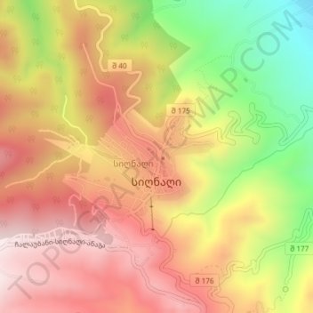
Nom : Carte topographique Sighnaghi, altitude, relief.
Lieu : Sighnaghi, Signagi Municipality, Kakheti, 4200, Georgia (41.61546 45.91125 41.62567 45.92879)
Altitude moyenne : 674 m
Altitude minimum : 350 m
Altitude maximum : 909 m
Autres cartes topographiques
Cliquez sur une carte pour visualiser sa topographie, son altitude et son relief.
Sighnaghi
Georgia > Signagi Municipality
The town has an area of 2.978 ha with 24.3% being residential. Signagi is approximately 113 km southeast of Tbilisi, the capital of Georgia. Signagi District is adjacent, on the town’s east and southwest sides. Signagi is situated in the eastern foothills of the Gombori Range, a watershed between the Iori…
Altitude moyenne : 739 m