
Faire un don
Équipez-vous pour votre prochaine aventure :
En tant que Partenaire Amazon, ce site perçoit une commission sur les achats éligibles sans surcoût pour vous.
Carte topographique Trail
Cliquez sur la carte pour afficher l’altitude.
Faire un don
Équipez-vous pour votre prochaine aventure :
En tant que Partenaire Amazon, ce site perçoit une commission sur les achats éligibles sans surcoût pour vous.
Trail
Summer climate in Trail is generally hot and dry with moderately cool nights. Temperatures often exceed 35 °C (95 °F) during summer afternoons, average 29 °C (84 °F). Thunderstorms are common during the late-Spring and Summer season, often moving into the valley from the south. The fall months bring dense river fog, especially overnight and in the morning, as a cold air inversion lingers above the relatively warm river surface. Winters are mild to cold with periods of moderate snowfall. Nearby villages such as Warfield, Fruitvale and especially Rossland receive greater amounts of snow due to higher elevation.
Faire un don
Équipez-vous pour votre prochaine aventure :
En tant que Partenaire Amazon, ce site perçoit une commission sur les achats éligibles sans surcoût pour vous.
À propos de cette carte
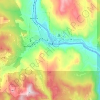
Nom : Carte topographique Trail, altitude, relief.
Altitude moyenne : 888 m
Altitude minimum : 395 m
Altitude maximum : 1 637 m
Faire un don
Équipez-vous pour votre prochaine aventure :
En tant que Partenaire Amazon, ce site perçoit une commission sur les achats éligibles sans surcoût pour vous.
Autres cartes topographiques
Cliquez sur une carte pour visualiser sa topographie, son altitude et son relief.
Stump Lake
Canada > British Columbia > Regional District of Kootenay Boundary > Area E (Beaverdell/West Boundary)
Altitude moyenne : 1 321 m