
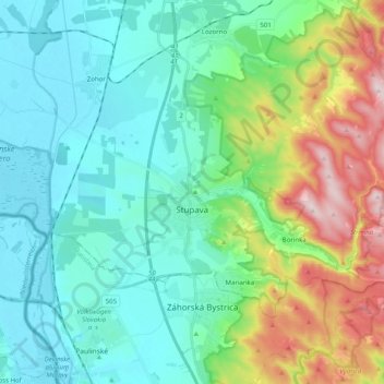
Carte topographique Stupava
Carte interactive
Cliquez sur la carte pour afficher l’altitude.
À propos de cette carte
Nom : Carte topographique Stupava, altitude, relief.
Altitude moyenne : 237 m
Altitude minimum : 137 m
Altitude maximum : 540 m
The town is located in the Záhorie lowland, under the Little Carpathians, around 15 km (9 mi) north of Bratislava at an altitude of 182 metres. It has 15, 095 inhabitants as of 2021 and has a land area of 67.17 km2 (26 sq mi). Apart from the core part of the city, Mást (German: Maaßt, Hungarian: Mászt), located just south of the core part of the city, is another part of Stupava. It has been initially a separate village with ethnic Croatian majority, which was formally annexed by Stupava in 1953.
Autres cartes topographiques
Cliquez sur une carte pour visualiser sa topographie, son altitude et son relief.
Marianka
Slovakia > Region of Bratislava > District of Malacky
Marianka, District of Malacky, Region of Bratislava, 900 33, Slovakia
Altitude moyenne : 249 m
Kuchyňa
Slovakia > Region of Bratislava > District of Malacky
Kuchyňa, District of Malacky, Region of Bratislava, 900 52, Slovakia
Altitude moyenne : 319 m
Malacky
Slovakia > Region of Bratislava > District of Malacky
Malacky, District of Malacky, Region of Bratislava, Slovakia
Altitude moyenne : 168 m
Borinka
Slovakia > Region of Bratislava > District of Malacky > Borinka
Borinka, District of Malacky, Region of Bratislava, Slovakia
Altitude moyenne : 304 m