
Carte topographique Rosyth
Carte interactive
Cliquez sur la carte pour afficher l’altitude.
À propos de cette carte
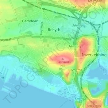
Nom : Carte topographique Rosyth, altitude, relief.
Lieu : Rosyth, Fife, Scotland, United Kingdom (56.01458 -3.46476 56.04760 -3.40341)
Altitude moyenne : 23 m
Altitude minimum : -5 m
Altitude maximum : 82 m
Autres cartes topographiques
Cliquez sur une carte pour visualiser sa topographie, son altitude et son relief.
Auchtermuchty
United Kingdom > Scotland > Fife
Auchtermuchty, Fife, Scotland, KY14 7AP, United Kingdom
Altitude moyenne : 108 m
Cupar
United Kingdom > Scotland > Fife
Cupar, Fife, Scotland, KY15 4BP, United Kingdom
Altitude moyenne : 75 m
Auchtertool
United Kingdom > Scotland > Fife
Auchtertool, Fife, Scotland, United Kingdom
Altitude moyenne : 113 m
Crail
United Kingdom > Scotland > Fife
Crail, Fife, Scotland, KY10 3UG, United Kingdom
Altitude moyenne : 21 m
Kinghorn
United Kingdom > Scotland > Fife
Kinghorn, Fife, Scotland, United Kingdom
Altitude moyenne : 30 m
Rankeilour
United Kingdom > Scotland > Fife > Springfield
Rankeilour, Springfield, Fife, Scotland, KY15 5RE, United Kingdom
Altitude moyenne : 48 m
Dunfermline
United Kingdom > Scotland > Fife
Dunfermline, Fife, Scotland, United Kingdom
Altitude moyenne : 114 m
Falkland
United Kingdom > Scotland > Fife
Falkland, Fife, Scotland, KY15 7BU, United Kingdom
Altitude moyenne : 133 m
Leuchars
United Kingdom > Scotland > Fife > Leuchars
Leuchars, Fife, Scotland, KY16 0HH, United Kingdom
Altitude moyenne : 22 m
Tayport
United Kingdom > Scotland > Fife
Tayport, Fife, Scotland, DD6 9AE, United Kingdom
Altitude moyenne : 22 m