
Carte topographique Hail Creek
Carte interactive
Cliquez sur la carte pour afficher l’altitude.
À propos de cette carte
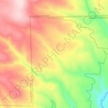
Nom : Carte topographique Hail Creek, altitude, relief.
Lieu : Hail Creek, Crook County, Oregon, United States of America (44.22241 -120.17710 44.24846 -120.12697)
Altitude moyenne : 1 412 m
Altitude minimum : 1 215 m
Altitude maximum : 1 555 m
Autres cartes topographiques
Cliquez sur une carte pour visualiser sa topographie, son altitude et son relief.
Redmond
United States of America > Oregon > Redmond
Redmond, Deschutes County, Oregon, 97756, United States of America
Altitude moyenne : 919 m
Tualatin River
United States of America > Oregon
Tualatin River, Clackamas County, Oregon, 97068, United States of America
Altitude moyenne : 82 m
McKenzie River
United States of America > Oregon
McKenzie River, Lane County, Oregon, 97478, United States of America
Altitude moyenne : 190 m
Forfar
United States of America > Oregon > Forfar
Forfar, Lincoln County, Oregon, United States of America
Altitude moyenne : 30 m
Wimer
United States of America > Oregon > Wimer
Wimer, Jackson County, Oregon, United States of America
Altitude moyenne : 417 m
Trask River
United States of America > Oregon
Trask River, Tillamook County, Oregon, 97141, United States of America
Altitude moyenne : 223 m
Springwater
United States of America > Oregon > Springwater
Springwater, Clackamas County, Oregon, 97023, United States of America
Altitude moyenne : 309 m
Millican
United States of America > Oregon > Millican
Millican, Deschutes County, Oregon, United States of America
Altitude moyenne : 1 337 m
Brickerville
United States of America > Oregon > Mapleton > Brickerville
Brickerville, Mapleton, Lane County, Oregon, 97453, United States of America
Altitude moyenne : 183 m
Tillamook Rock Light
United States of America > Oregon
Tillamook Rock Light, Tillamook Rock Lighthouse Trail, Clatsop County, Oregon, United States of America
Altitude moyenne : 0 m
Oak Grove
United States of America > Oregon > Oak Grove
Oak Grove, Clackamas County, Oregon, 97268, United States of America
Altitude moyenne : 49 m
Saum Creek
United States of America > Oregon
Saum Creek, Washington County, Oregon, 97062, United States of America
Altitude moyenne : 110 m
Pilot Rock
United States of America > Oregon > Pilot Rock
Pilot Rock, Umatilla County, Oregon, United States of America
Altitude moyenne : 527 m
Thousand Springs
United States of America > Oregon
Thousand Springs, Thousand Springs Road, Jackson County, Oregon, United States of America
Altitude moyenne : 1 536 m
Saint Joseph
United States of America > Oregon > Saint Joseph
Saint Joseph, Yamhill County, Oregon, 97127, United States of America
Altitude moyenne : 44 m
Jones Creek
United States of America > Oregon
Jones Creek, Josephine County, Oregon, 97506, United States of America
Altitude moyenne : 333 m