
Carte topographique Hacklebarney
Carte interactive
Cliquez sur la carte pour afficher l’altitude.
À propos de cette carte
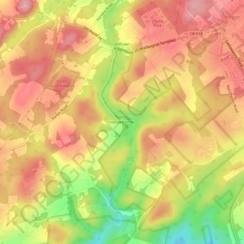
Nom : Carte topographique Hacklebarney, altitude, relief.
Altitude moyenne : 230 m
Altitude minimum : 142 m
Altitude maximum : 283 m
Autres cartes topographiques
Cliquez sur une carte pour visualiser sa topographie, son altitude et son relief.
Hacklebarney State Park
United States of America > New Jersey > Chester Township > Hacklebarney
Hacklebarney State Park, State Park Road, Hacklebarney, Chester Township, Morris County, New Jersey, 07955, United States of America
Altitude moyenne : 166 m