
Carte topographique Bengaluru
Carte interactive
Cliquez sur la carte pour afficher l’altitude.
À propos de cette carte
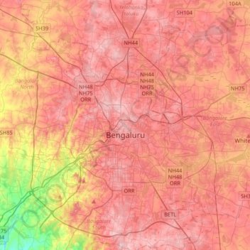
Nom : Carte topographique Bengaluru, altitude, relief.
Altitude moyenne : 881 m
Altitude minimum : 722 m
Altitude maximum : 965 m
Bangalore (/bæŋɡəˈlɔːr/), officially Bengaluru (Kannada pronunciation: [ˈbeŋgɐɭuːɾu] (listen)), is the capital and largest city of the Indian state of Karnataka. It has a population of more than 8 million and a metropolitan population of around 11 million, making it the third most populous city and fifth most populous urban agglomeration in India, as well as the largest city in South India, and the 27th largest city in the world. Located on the Deccan Plateau, at a height of over 900 m (3,000 ft) above sea level, Bangalore has a pleasant climate throughout the year, with its parks and green spaces earning it the reputation as the "Garden City" of India. Its elevation is the highest among the major cities of India. An aerospace and electronics hub since the 1960s, Bangalore is widely regarded as the "Silicon Valley of India" because of its role as the nation's leading information technology (IT) exporter. In the Ease of Living Index 2020 (published by the Ministry of Housing and Urban Affairs), it was ranked the most livable Indian city with a population of over a million. It also ranks among the highest Indian cities in terms of global livability rankings as well.
Autres cartes topographiques
Cliquez sur une carte pour visualiser sa topographie, son altitude et son relief.
Chikkabidarakallu
India > Karnataka > Bangalore North
Chikkabidarakallu, Bangalore North, Bengaluru Urban, Karnataka, 560073, India
Altitude moyenne : 877 m
Sampangiram Nagar Ward
India > Karnataka > Bangalore North > Bengaluru
Sampangiram Nagar Ward, East Zone, Bengaluru, Bangalore North, Bengaluru Urban District, Karnataka, India, Cubbon Park
Altitude moyenne : 917 m
Ullal Lake
India > Karnataka > Bangalore North > Bengaluru
Ullal Lake, Ullalu Upanagara, Ullalu, Rajarajeshwari Nagar Zone, Bengaluru, Bangalore North, Bangalore Urban, Karnataka, India
Altitude moyenne : 843 m
Vidyaranyapura
India > Karnataka > Bangalore North > Bengaluru
Vidyaranyapura, Yelahanka Zone, Bengaluru, Bangalore North, Bangalore Urban, Karnataka, India
Altitude moyenne : 920 m
HBR Layout
India > Karnataka > Bangalore North > Bengaluru
HBR Layout, East Zone, Bengaluru, Bangalore North, Bangalore Urban, Karnataka, 560045, India
Altitude moyenne : 893 m
Kammanahalli
India > Karnataka > Bangalore North > Bengaluru
Kammanahalli, East Zone, Bengaluru, Bangalore North, Bangalore Urban, Karnataka, 560033, India
Altitude moyenne : 908 m
Bagaluru
India > Karnataka > Bangalore North > Bagaluru
Bagaluru, Bangalore North, Bangalore Urban, Karnataka, 562149, India
Altitude moyenne : 899 m
Kalenahalli
India > Karnataka > Bangalore North > Muthkuru > Kalenahalli
Kalenahalli, Muthkuru, Bangalore North, Bangalore Urban, Karnataka, 560089, India
Altitude moyenne : 877 m