Géolocaliser

Carte topographique Dillans Scrub

Cliquez sur la carte pour afficher l’altitude.

À propos de cette carte

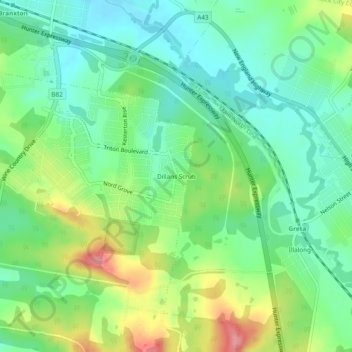
Nom : Carte topographique Dillans Scrub, altitude, relief.

Lieu : Dillans Scrub, Cessnock City Council, New South Wales, 2334, Australia (-32.70167 151.34778 -32.66167 151.38778)

Altitude moyenne : 67 m

Altitude minimum : 31 m

Altitude maximum : 135 m

Autres cartes topographiques

Cliquez sur une carte pour visualiser sa topographie, son altitude et son relief.

Sydney

Australia > New South Wales

Sydney's topography is characterized by a diverse landscape that seamlessly blends coastal features with inland plateaus. The city is divided into two primary regions: the relatively flat Cumberland Plain to the south and west of Sydney Harbour, and the elevated Hornsby Plateau to the north. The Cumberland…

Altitude moyenne : 53 m

Armidale

Australia > New South Wales

Altitude moyenne : 1 036 m

Casino

Australia > New South Wales

Altitude moyenne : 32 m

Newcastle

Australia > New South Wales

Altitude moyenne : 5 m

Goulburn

Australia > New South Wales

Owing to its elevation, Goulburn has an oceanic climate (Cfb) with warm summers and cool winters; with a high diurnal range. Its climate is variable much of the year, though generally dry with maximum temperatures ranging from 11.8 °C (53.2 °F) in July to 28.3 °C (82.9 °F) in January. Rainfall is…

Altitude moyenne : 666 m

Port Macquarie

Australia > New South Wales

Altitude moyenne : 5 m

Parramatta

Australia > New South Wales

Altitude moyenne : 22 m

Wondabyne

Australia > New South Wales > Gosford

Altitude moyenne : 81 m

St Ives

Australia > New South Wales

Altitude moyenne : 125 m

Leura

Australia > New South Wales

Leura's elevation of 985 metres (3,232 ft) AHD  leads to occasional snowfall in winter and a climate that reflects all four seasons distinctly.

Altitude moyenne : 880 m

Mudgee

Australia > New South Wales

Altitude moyenne : 535 m

Sydney

Australia > New South Wales > Sydney

Altitude moyenne : 23 m

Wahroonga

Australia > New South Wales

Altitude moyenne : 159 m

Moore Park

Australia > New South Wales > Sydney

Altitude moyenne : 43 m

Camden Council

Australia > New South Wales

Altitude moyenne : 90 m

Gulmarrad

Australia > New South Wales

Altitude moyenne : 10 m

Lismore

Australia > New South Wales

Altitude moyenne : 23 m

Blue Mountains

Australia > New South Wales

A sandstone plateau dominated by a landscape of endless eucalyptus forests, the Blue Mountains are located at the top of a 470-million-year-old quartzite. In the Permian period, a shallow sea covered the region, when rivers brought shales, siltstones and mudstones. Then during the Mesozoic period, rivers…

Altitude moyenne : 566 m

Mosman

Australia > New South Wales > Sydney

Altitude moyenne : 29 m

Penrith

Australia > New South Wales > Sydney > Penrith

Penrith is a city in New South Wales, Australia, located in Greater Western Sydney, 55 kilometres (31 mi) west of the Sydney central business district on the banks of the Nepean River, on the outskirts of the Cumberland Plain. Its elevation is 32 metres (105 ft).

Altitude moyenne : 34 m

Katoomba

Australia > New South Wales

Altitude moyenne : 904 m

Nimbin

Australia > New South Wales

Altitude moyenne : 235 m

Hornsby

Australia > New South Wales > Sydney

Altitude moyenne : 160 m

Coraki

Australia > New South Wales

Altitude moyenne : 6 m

Northern Beaches

Australia > New South Wales > Sydney

Altitude moyenne : 67 m

Red Head

Australia > New South Wales

Altitude moyenne : 10 m

Ganmain

Australia > New South Wales

Altitude moyenne : 201 m

Byron Bay

Australia > New South Wales

Byron Bay, located in northeastern New South Wales, Australia, is characterized by diverse topography shaped by its geological history. The town is part of the erosion caldera of the ancient Tweed Volcano, which erupted approximately 23 million years ago, resulting in the rich volcanic soils that define the…

Altitude moyenne : 7 m

Berowra

Australia > New South Wales > Sydney

Berowra is located 44 kilometres north of the Sydney CBD and lies at an altitude of 215 metres. Surrounded by bushland, it borders the national parks of both the Berowra Valley and Ku-ring-gai Chase.

Altitude moyenne : 144 m

Illawarra

Australia > New South Wales

Altitude moyenne : 234 m

Grafton

Australia > New South Wales

Altitude moyenne : 5 m

Berry

Australia > New South Wales

Altitude moyenne : 38 m

Glen Innes

Australia > New South Wales

Altitude moyenne : 1 083 m

Gloucester

Australia > New South Wales > Gloucester

Altitude moyenne : 104 m

Umina Beach

Australia > New South Wales

Altitude moyenne : 38 m

Pymble

Australia > New South Wales > Sydney

Altitude moyenne : 125 m

Coogee

Australia > New South Wales

Altitude moyenne : 35 m

Forestville

Australia > New South Wales > Sydney

Altitude moyenne : 92 m

Rose Bay

Australia > New South Wales

Altitude moyenne : 31 m

Collaroy Plateau

Australia > New South Wales > Sydney

Altitude moyenne : 30 m

Gordon

Australia > New South Wales > Sydney

Altitude moyenne : 101 m

Crookwell

Australia > New South Wales

Crookwell is a small town located in the Southern Tablelands of New South Wales, Australia, in the Upper Lachlan Shire. At the 2016 census, Crookwell had a population of 2,641. The town is at a relatively high altitude of 887 metres and there are several snowfalls during the winter months. The nearest major…

Altitude moyenne : 904 m

North Sydney

Australia > New South Wales > Sydney

Altitude moyenne : 50 m

Lower Portland

Australia > New South Wales

Altitude moyenne : 67 m

New England National Park

Australia > New South Wales

The park lies within the Eastern Australian temperate forests ecoregion. It is noted for the wide variety of plant and animal species. The diverse vegetation in the park includes sub-tropical, warm temperate and cool temperate rainforest in the higher altitudes. There are also areas of sclerophyll forest,…

Altitude moyenne : 559 m

Raymond Terrace

Australia > New South Wales

Altitude moyenne : 9 m

Orange

Australia > New South Wales

Orange is a city in the Central Tablelands region of New South Wales, Australia. It is 254 km (158 mi) west of the state capital, Sydney [206 km (128 mi) on a great circle], at an altitude of 862 metres (2,828 ft). Orange had an estimated urban population of 40,493 as of June 2018 making the city a significant…

Altitude moyenne : 852 m

Kurrajong

Australia > New South Wales > Sydney

Altitude moyenne : 244 m

Tenterfield

Australia > New South Wales

Altitude moyenne : 891 m

Macleay River

Australia > New South Wales

Altitude moyenne : 308 m

Waratah West

Australia > New South Wales > Newcastle

Altitude moyenne : 27 m

Ulladulla

Australia > New South Wales

Altitude moyenne : 21 m

Mount Victoria

Australia > New South Wales

Mount Victoria (postcode: 2786) is a small township in the Blue Mountains of New South Wales, Australia. Mount Victoria is geographically the western most village and suburb of Greater Sydney on the great western highway in the City of Blue Mountains, located about 120 kilometres (75 mi) west-northwest by road…

Altitude moyenne : 901 m

Moruya

Australia > New South Wales

Altitude moyenne : 37 m

Killarney Vale

Australia > New South Wales

Altitude moyenne : 8 m

Campbelltown

Australia > New South Wales

Altitude moyenne : 96 m

Singleton Council

Australia > New South Wales

Altitude moyenne : 238 m

Yass

Australia > New South Wales

Yass is located 280 km south-west of Sydney, on the Hume Highway. The Yass River, which is a tributary of the Murrumbidgee River, flows through the town. Yass is 59 km from Canberra; lying at an elevation of 505 m AMSL.

Altitude moyenne : 533 m

Alstonville

Australia > New South Wales

Altitude moyenne : 131 m

Northmead

Australia > New South Wales

Altitude moyenne : 52 m

Avalon Beach

Australia > New South Wales

Altitude moyenne : 24 m

Ourimbah

Australia > New South Wales

Altitude moyenne : 84 m

Hat Head

Australia > New South Wales

Altitude moyenne : 4 m

Balgowlah

Australia > New South Wales > Sydney

Altitude moyenne : 40 m

Wauchope

Australia > New South Wales

Altitude moyenne : 32 m

West Pennant Hills

Australia > New South Wales

Altitude moyenne : 130 m

Hill Top

Australia > New South Wales

Altitude moyenne : 543 m

Kiama

Australia > New South Wales

Altitude moyenne : 29 m

Morton National Park

Australia > New South Wales

Altitude moyenne : 427 m

Yarrowitch

Australia > New South Wales

Altitude moyenne : 890 m

Manyana

Australia > New South Wales

Altitude moyenne : 17 m

Rainbow Flat

Australia > New South Wales

Altitude moyenne : 44 m

Auburn

Australia > New South Wales > Sydney

Altitude moyenne : 21 m

Upper Colo

Australia > New South Wales

Altitude moyenne : 157 m

Sunny Corner

Australia > New South Wales

Altitude moyenne : 1 119 m

Mallee

Australia > New South Wales

Altitude moyenne : 64 m

Summer Hill

Australia > New South Wales

Altitude moyenne : 29 m

Emerald Beach

Australia > New South Wales

Altitude moyenne : 14 m

Moonbah

Australia > New South Wales

Altitude moyenne : 1 129 m

Mullaway

Australia > New South Wales

Altitude moyenne : 10 m

Federation Council

Australia > New South Wales

Altitude moyenne : 143 m

Grahamstown Dam

Australia > New South Wales

Altitude moyenne : 14 m

Hoxton Park

Australia > New South Wales

Altitude moyenne : 38 m

Gwydir Shire Council

Australia > New South Wales

Altitude moyenne : 431 m

St Georges Basin

Australia > New South Wales

Altitude moyenne : 18 m

Équipez-vous pour votre prochaine aventure :

🔦Mini lampe LED porte-clés - Éclairage d'appoint toujours à portée de main
🪶Équipement camping ultraléger - Optimisation du poids en trek
🪑Chaise de camping pliable - Légère pour se reposer face aux panoramas
🔋Batteries externes outdoor - Recharge des appareils en pleine nature
🧊Glacières souples - Transport nourriture et boissons

En tant que Partenaire Amazon, ce site perçoit une commission sur les achats éligibles sans surcoût pour vous.